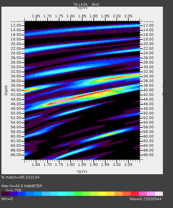
L42A Oliver, Polo, IL, USA - Earthquake Result Viewer

Earthquake location: Andreanof Islands, Aleutian Is.
Earthquake latitude/longitude: 51.5/-175.2
Earthquake time(UTC): 2013/08/30 (242) 16:25:02 GMT
Earthquake Depth: 29 km
Earthquake Magnitude: 7.0 MWW, 6.5 ML, 6.8 MI, 6.9 MWC, 6.9 MWB, 7.0 MWW, 7.0 MI, 7.0 MWC
Earthquake Catalog/Contributor: NEIC PDE/NEIC COMCAT
Network: TA USArray Transportable Network (new EarthScope stations)
Station: L42A Oliver, Polo, IL, USA
Lat/Lon: 42.00 N/89.67 W
Elevation: 257 m
Distance: 56.2 deg
Az: 63.446 deg
Baz: 311.446 deg
Ray Param: 0.06426642
Estimated Moho Depth: 44.5 km
Estimated Crust Vp/Vs: 1.75
Assumed Crust Vp: 6.571 km/s
Estimated Crust Vs: 3.744 km/s
Estimated Crust Poisson's Ratio: 0.26
Radial Match: 95.032104 %
Radial Bump: 400
Transverse Match: 72.55169 %
Transverse Bump: 400
SOD ConfigId: 626651
Insert Time: 2014-04-18 05:21:59.461 +0000
GWidth: 2.5
Max Bumps: 400
Tol: 0.001

Signal To Noise

ChannelStoNSTALTA
TA:L42A: :BHZ:20130830T16:34:08.575024Z14.7853642.2897786E-61.5486792E-7
TA:L42A: :BHN:20130830T16:34:08.575024Z6.773259.4177784E-71.3904372E-7
TA:L42A: :BHE:20130830T16:34:08.575024Z5.62994868.2252535E-71.460982E-7
Arrivals
Ps5.4 SECOND
PpPs18 SECOND
PsPs/PpSs23 SECOND