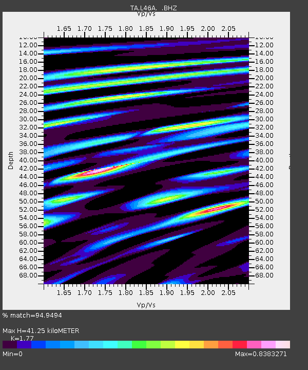
L46A Eue Claire, MI, USA - Earthquake Result Viewer
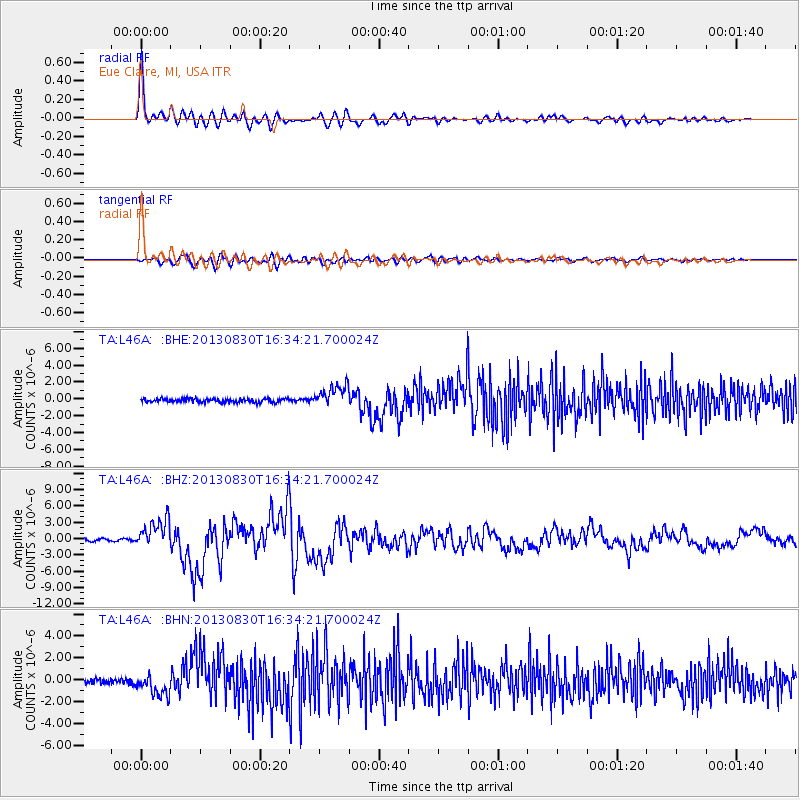
Earthquake location: Andreanof Islands, Aleutian Is.
Earthquake latitude/longitude: 51.5/-175.2
Earthquake time(UTC): 2013/08/30 (242) 16:25:02 GMT
Earthquake Depth: 29 km
Earthquake Magnitude: 7.0 MWW, 6.5 ML, 6.8 MI, 6.9 MWC, 6.9 MWB, 7.0 MWW, 7.0 MI, 7.0 MWC
Earthquake Catalog/Contributor: NEIC PDE/NEIC COMCAT
Network: TA USArray Transportable Network (new EarthScope stations)
Station: L46A Eue Claire, MI, USA
Lat/Lon: 42.01 N/86.30 W
Elevation: 223 m
Distance: 58.0 deg
Az: 61.435 deg
Baz: 312.602 deg
Ray Param: 0.06306076
Estimated Moho Depth: 41.25 km
Estimated Crust Vp/Vs: 1.77
Assumed Crust Vp: 6.483 km/s
Estimated Crust Vs: 3.662 km/s
Estimated Crust Poisson's Ratio: 0.27
Radial Match: 94.9494 %
Radial Bump: 400
Transverse Match: 76.07365 %
Transverse Bump: 400
SOD ConfigId: 626651
Insert Time: 2014-04-18 05:22:04.076 +0000
GWidth: 2.5
Max Bumps: 400
Tol: 0.001

Signal To Noise

ChannelStoNSTALTA
TA:L46A: :BHZ:20130830T16:34:21.700024Z11.5620832.6448893E-62.2875543E-7
TA:L46A: :BHN:20130830T16:34:21.700024Z4.48936561.0475768E-62.3334628E-7
TA:L46A: :BHE:20130830T16:34:21.700024Z6.09653951.315291E-62.1574387E-7
Arrivals
Ps5.2 SECOND
PpPs17 SECOND
PsPs/PpSs22 SECOND