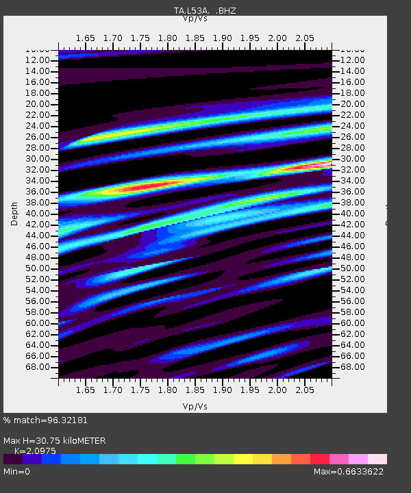
L53A Girard, PA, USA - Earthquake Result Viewer

Earthquake location: Andreanof Islands, Aleutian Is.
Earthquake latitude/longitude: 51.5/-175.2
Earthquake time(UTC): 2013/08/30 (242) 16:25:02 GMT
Earthquake Depth: 29 km
Earthquake Magnitude: 7.0 MWW, 6.5 ML, 6.8 MI, 6.9 MWC, 6.9 MWB, 7.0 MWW, 7.0 MI, 7.0 MWC
Earthquake Catalog/Contributor: NEIC PDE/NEIC COMCAT
Network: TA USArray Transportable Network (new EarthScope stations)
Station: L53A Girard, PA, USA
Lat/Lon: 41.95 N/80.26 W
Elevation: 355 m
Distance: 61.3 deg
Az: 57.883 deg
Baz: 314.831 deg
Ray Param: 0.060899172
Estimated Moho Depth: 30.75 km
Estimated Crust Vp/Vs: 2.10
Assumed Crust Vp: 6.483 km/s
Estimated Crust Vs: 3.091 km/s
Estimated Crust Poisson's Ratio: 0.35
Radial Match: 96.32181 %
Radial Bump: 400
Transverse Match: 84.6345 %
Transverse Bump: 400
SOD ConfigId: 626651
Insert Time: 2014-04-18 05:22:13.936 +0000
GWidth: 2.5
Max Bumps: 400
Tol: 0.001

Signal To Noise

ChannelStoNSTALTA
TA:L53A: :BHZ:20130830T16:34:44.325024Z20.0709232.8256925E-61.4078537E-7
TA:L53A: :BHN:20130830T16:34:44.325024Z4.31401169.2281925E-72.139121E-7
TA:L53A: :BHE:20130830T16:34:44.325024Z5.27997549.2228487E-71.7467598E-7
Arrivals
Ps5.4 SECOND
PpPs14 SECOND
PsPs/PpSs20 SECOND