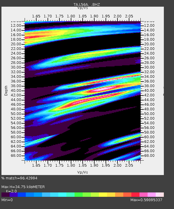
L56A Greenwood, NY, USA - Earthquake Result Viewer
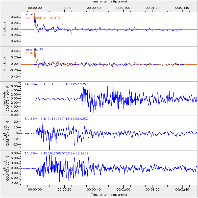
Earthquake location: Andreanof Islands, Aleutian Is.
Earthquake latitude/longitude: 51.5/-175.2
Earthquake time(UTC): 2013/08/30 (242) 16:25:02 GMT
Earthquake Depth: 29 km
Earthquake Magnitude: 7.0 MWW, 6.5 ML, 6.8 MI, 6.9 MWC, 6.9 MWB, 7.0 MWW, 7.0 MI, 7.0 MWC
Earthquake Catalog/Contributor: NEIC PDE/NEIC COMCAT
Network: TA USArray Transportable Network (new EarthScope stations)
Station: L56A Greenwood, NY, USA
Lat/Lon: 42.14 N/77.56 W
Elevation: 688 m
Distance: 62.6 deg
Az: 56.117 deg
Baz: 315.804 deg
Ray Param: 0.060067434
Estimated Moho Depth: 34.75 km
Estimated Crust Vp/Vs: 2.00
Assumed Crust Vp: 6.476 km/s
Estimated Crust Vs: 3.238 km/s
Estimated Crust Poisson's Ratio: 0.33
Radial Match: 96.42994 %
Radial Bump: 362
Transverse Match: 88.96895 %
Transverse Bump: 400
SOD ConfigId: 626651
Insert Time: 2014-04-18 05:22:22.805 +0000
GWidth: 2.5
Max Bumps: 400
Tol: 0.001

Signal To Noise

ChannelStoNSTALTA
TA:L56A: :BHZ:20130830T16:34:52.925Z17.2584135.4154084E-63.1378372E-7
TA:L56A: :BHN:20130830T16:34:52.925Z6.49368761.6634119E-62.561583E-7
TA:L56A: :BHE:20130830T16:34:52.925Z6.3394792.0957116E-63.3058106E-7
Arrivals
Ps5.6 SECOND
PpPs15 SECOND
PsPs/PpSs21 SECOND