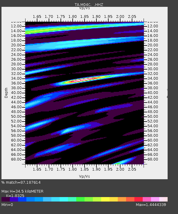
M04C Macdoel, CA, USA - Earthquake Result Viewer
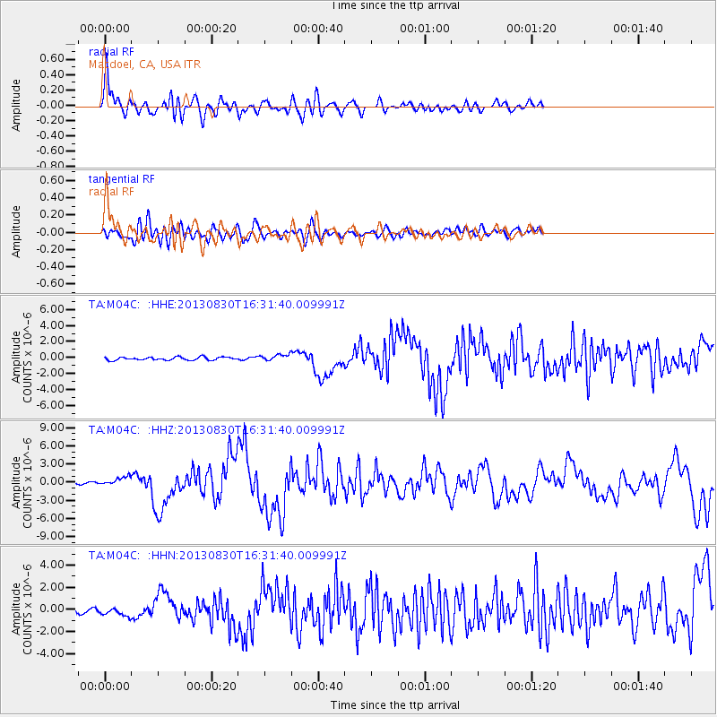
Earthquake location: Andreanof Islands, Aleutian Is.
Earthquake latitude/longitude: 51.5/-175.2
Earthquake time(UTC): 2013/08/30 (242) 16:25:02 GMT
Earthquake Depth: 29 km
Earthquake Magnitude: 7.0 MWW, 6.5 ML, 6.8 MI, 6.9 MWC, 6.9 MWB, 7.0 MWW, 7.0 MI, 7.0 MWC
Earthquake Catalog/Contributor: NEIC PDE/NEIC COMCAT
Network: TA USArray Transportable Network (new EarthScope stations)
Station: M04C Macdoel, CA, USA
Lat/Lon: 41.78 N/121.84 W
Elevation: 1391 m
Distance: 37.2 deg
Az: 83.701 deg
Baz: 303.895 deg
Ray Param: 0.07623945
Estimated Moho Depth: 34.5 km
Estimated Crust Vp/Vs: 1.83
Assumed Crust Vp: 6.566 km/s
Estimated Crust Vs: 3.583 km/s
Estimated Crust Poisson's Ratio: 0.29
Radial Match: 87.187614 %
Radial Bump: 400
Transverse Match: 71.73125 %
Transverse Bump: 400
SOD ConfigId: 626651
Insert Time: 2014-04-18 05:22:32.823 +0000
GWidth: 2.5
Max Bumps: 400
Tol: 0.001

Signal To Noise

ChannelStoNSTALTA
TA:M04C: :HHZ:20130830T16:31:40.009991Z4.78007467.462533E-71.5611751E-7
TA:M04C: :HHN:20130830T16:31:40.009991Z2.58467583.3881855E-71.3108743E-7
TA:M04C: :HHE:20130830T16:31:40.009991Z2.0913654.0043818E-71.9147215E-7
Arrivals
Ps4.7 SECOND
PpPs14 SECOND
PsPs/PpSs19 SECOND