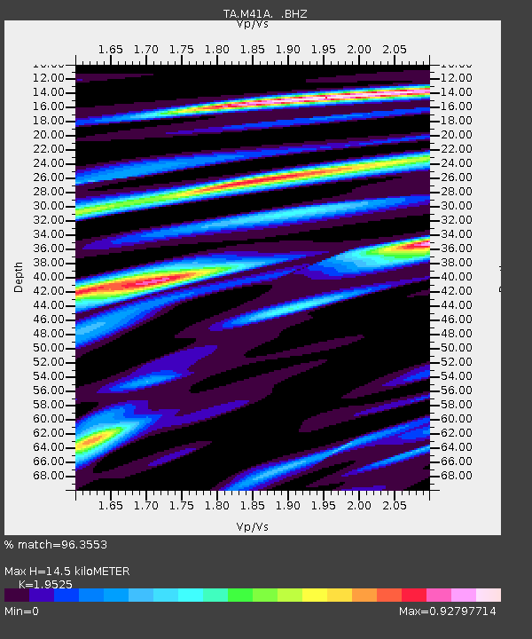
M41A Milan, IL, USA - Earthquake Result Viewer

Earthquake location: Andreanof Islands, Aleutian Is.
Earthquake latitude/longitude: 51.5/-175.2
Earthquake time(UTC): 2013/08/30 (242) 16:25:02 GMT
Earthquake Depth: 29 km
Earthquake Magnitude: 7.0 MWW, 6.5 ML, 6.8 MI, 6.9 MWC, 6.9 MWB, 7.0 MWW, 7.0 MI, 7.0 MWC
Earthquake Catalog/Contributor: NEIC PDE/NEIC COMCAT
Network: TA USArray Transportable Network (new EarthScope stations)
Station: M41A Milan, IL, USA
Lat/Lon: 41.38 N/90.54 W
Elevation: 226 m
Distance: 56.1 deg
Az: 64.536 deg
Baz: 311.473 deg
Ray Param: 0.06431531
Estimated Moho Depth: 14.5 km
Estimated Crust Vp/Vs: 1.95
Assumed Crust Vp: 6.498 km/s
Estimated Crust Vs: 3.328 km/s
Estimated Crust Poisson's Ratio: 0.32
Radial Match: 96.3553 %
Radial Bump: 349
Transverse Match: 86.8542 %
Transverse Bump: 400
SOD ConfigId: 626651
Insert Time: 2014-04-18 05:22:33.064 +0000
GWidth: 2.5
Max Bumps: 400
Tol: 0.001

Signal To Noise

ChannelStoNSTALTA
TA:M41A: :BHZ:20130830T16:34:08.024976Z21.9832882.7761887E-61.2628632E-7
TA:M41A: :BHN:20130830T16:34:08.024976Z5.3568041.2241501E-62.2852248E-7
TA:M41A: :BHE:20130830T16:34:08.024976Z5.9586111.2163316E-62.0413005E-7
Arrivals
Ps2.2 SECOND
PpPs6.3 SECOND
PsPs/PpSs8.5 SECOND