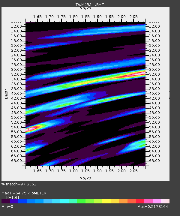
M49A Liberty Center, OH, USA - Earthquake Result Viewer
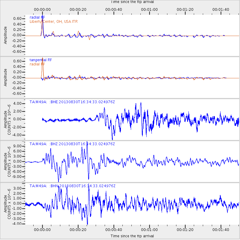
Earthquake location: Andreanof Islands, Aleutian Is.
Earthquake latitude/longitude: 51.5/-175.2
Earthquake time(UTC): 2013/08/30 (242) 16:25:02 GMT
Earthquake Depth: 29 km
Earthquake Magnitude: 7.0 MWW, 6.5 ML, 6.8 MI, 6.9 MWC, 6.9 MWB, 7.0 MWW, 7.0 MI, 7.0 MWC
Earthquake Catalog/Contributor: NEIC PDE/NEIC COMCAT
Network: TA USArray Transportable Network (new EarthScope stations)
Station: M49A Liberty Center, OH, USA
Lat/Lon: 41.47 N/83.98 W
Elevation: 203 m
Distance: 59.7 deg
Az: 60.507 deg
Baz: 313.66 deg
Ray Param: 0.061990067
Estimated Moho Depth: 54.75 km
Estimated Crust Vp/Vs: 1.61
Assumed Crust Vp: 6.498 km/s
Estimated Crust Vs: 4.036 km/s
Estimated Crust Poisson's Ratio: 0.19
Radial Match: 97.6352 %
Radial Bump: 288
Transverse Match: 89.75073 %
Transverse Bump: 400
SOD ConfigId: 626651
Insert Time: 2014-04-18 05:22:42.741 +0000
GWidth: 2.5
Max Bumps: 400
Tol: 0.001

Signal To Noise

ChannelStoNSTALTA
TA:M49A: :BHZ:20130830T16:34:33.024976Z20.1785813.0407666E-61.5069278E-7
TA:M49A: :BHN:20130830T16:34:33.024976Z5.6582819.2932453E-71.642415E-7
TA:M49A: :BHE:20130830T16:34:33.024976Z7.16657731.229369E-61.71542E-7
Arrivals
Ps5.4 SECOND
PpPs21 SECOND
PsPs/PpSs26 SECOND