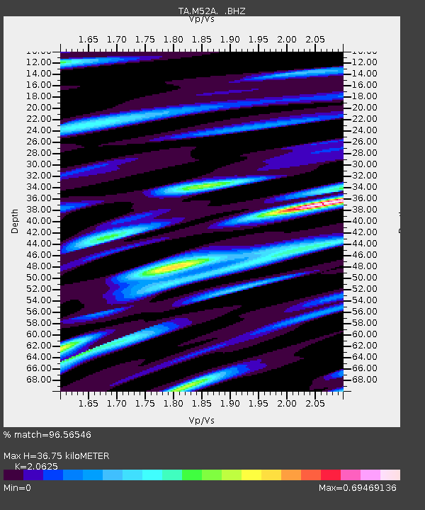
M52A Chesterland, OH, USA - Earthquake Result Viewer

Earthquake location: Andreanof Islands, Aleutian Is.
Earthquake latitude/longitude: 51.5/-175.2
Earthquake time(UTC): 2013/08/30 (242) 16:25:02 GMT
Earthquake Depth: 29 km
Earthquake Magnitude: 7.0 MWW, 6.5 ML, 6.8 MI, 6.9 MWC, 6.9 MWB, 7.0 MWW, 7.0 MI, 7.0 MWC
Earthquake Catalog/Contributor: NEIC PDE/NEIC COMCAT
Network: TA USArray Transportable Network (new EarthScope stations)
Station: M52A Chesterland, OH, USA
Lat/Lon: 41.54 N/81.36 W
Elevation: 382 m
Distance: 61.0 deg
Az: 58.877 deg
Baz: 314.583 deg
Ray Param: 0.06109198
Estimated Moho Depth: 36.75 km
Estimated Crust Vp/Vs: 2.06
Assumed Crust Vp: 6.483 km/s
Estimated Crust Vs: 3.143 km/s
Estimated Crust Poisson's Ratio: 0.35
Radial Match: 96.56546 %
Radial Bump: 400
Transverse Match: 86.612495 %
Transverse Bump: 400
SOD ConfigId: 626651
Insert Time: 2014-04-18 05:22:52.012 +0000
GWidth: 2.5
Max Bumps: 400
Tol: 0.001

Signal To Noise

ChannelStoNSTALTA
TA:M52A: :BHZ:20130830T16:34:42.349011Z19.5010412.8962536E-61.485179E-7
TA:M52A: :BHN:20130830T16:34:42.349011Z4.88910159.580426E-71.9595475E-7
TA:M52A: :BHE:20130830T16:34:42.349011Z7.08579161.076128E-61.5187125E-7
Arrivals
Ps6.3 SECOND
PpPs17 SECOND
PsPs/PpSs23 SECOND