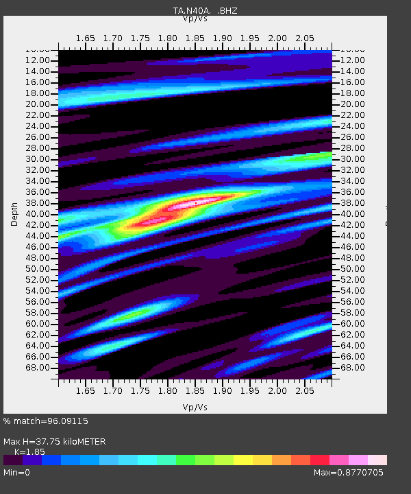
N40A Mertquake, Salem, IA, USA - Earthquake Result Viewer
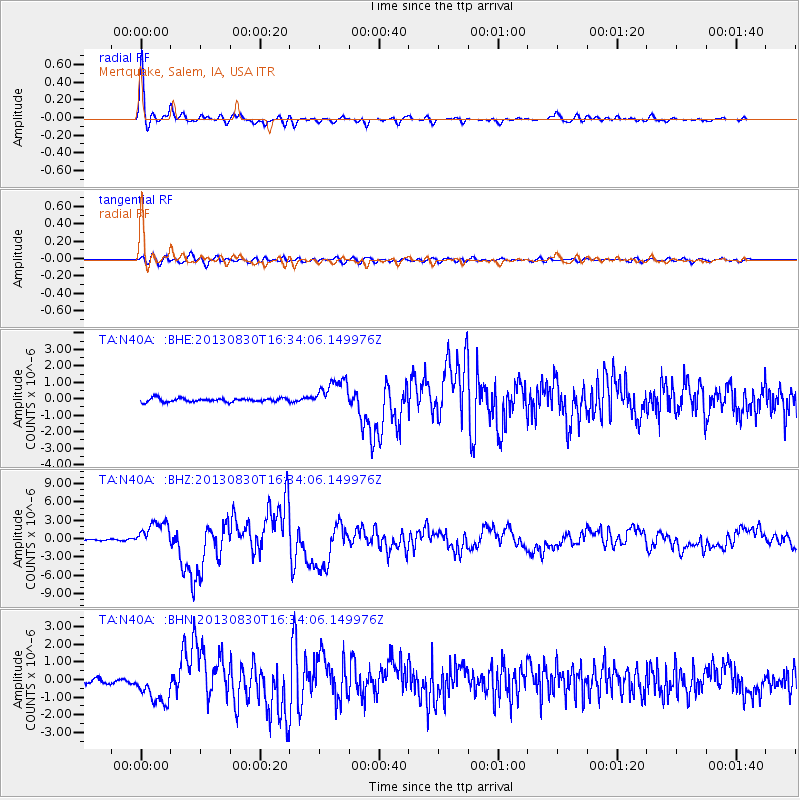
Earthquake location: Andreanof Islands, Aleutian Is.
Earthquake latitude/longitude: 51.5/-175.2
Earthquake time(UTC): 2013/08/30 (242) 16:25:02 GMT
Earthquake Depth: 29 km
Earthquake Magnitude: 7.0 MWW, 6.5 ML, 6.8 MI, 6.9 MWC, 6.9 MWB, 7.0 MWW, 7.0 MI, 7.0 MWC
Earthquake Catalog/Contributor: NEIC PDE/NEIC COMCAT
Network: TA USArray Transportable Network (new EarthScope stations)
Station: N40A Mertquake, Salem, IA, USA
Lat/Lon: 40.88 N/91.58 W
Elevation: 208 m
Distance: 55.8 deg
Az: 65.608 deg
Baz: 311.391 deg
Ray Param: 0.06448796
Estimated Moho Depth: 37.75 km
Estimated Crust Vp/Vs: 1.85
Assumed Crust Vp: 6.498 km/s
Estimated Crust Vs: 3.512 km/s
Estimated Crust Poisson's Ratio: 0.29
Radial Match: 96.09115 %
Radial Bump: 332
Transverse Match: 81.94817 %
Transverse Bump: 400
SOD ConfigId: 626651
Insert Time: 2014-04-18 05:23:21.888 +0000
GWidth: 2.5
Max Bumps: 400
Tol: 0.001

Signal To Noise

ChannelStoNSTALTA
TA:N40A: :BHZ:20130830T16:34:06.149976Z22.4312422.1911997E-69.7685174E-8
TA:N40A: :BHN:20130830T16:34:06.149976Z5.35479939.734899E-71.8179766E-7
TA:N40A: :BHE:20130830T16:34:06.149976Z8.185198.963488E-71.0950862E-7
Arrivals
Ps5.2 SECOND
PpPs16 SECOND
PsPs/PpSs21 SECOND