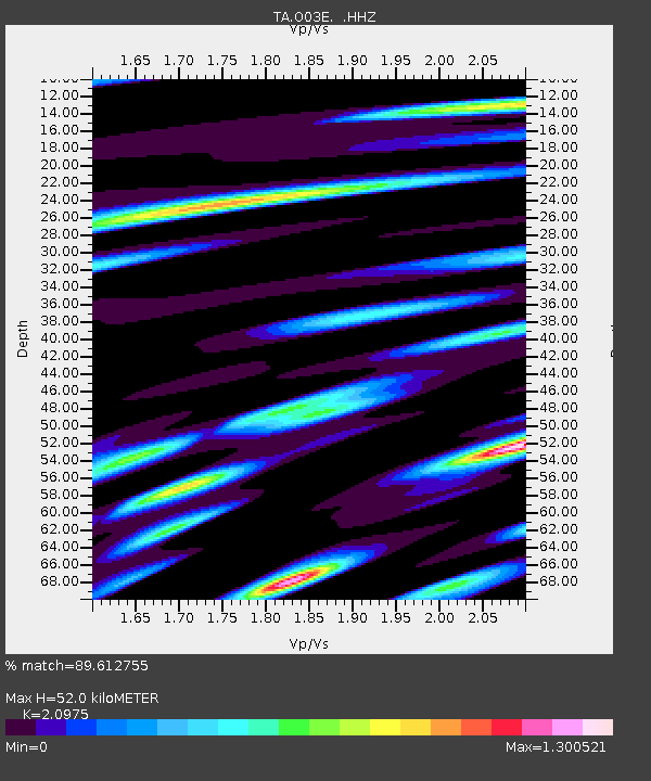
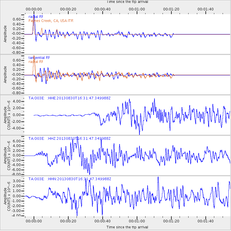
O03E Paynes Creek, CA, USA - Earthquake Result Viewer

Earthquake location: Andreanof Islands, Aleutian Is.
Earthquake latitude/longitude: 51.5/-175.2
Earthquake time(UTC): 2013/08/30 (242) 16:25:02 GMT
Earthquake Depth: 29 km
Earthquake Magnitude: 7.0 MWW, 6.5 ML, 6.8 MI, 6.9 MWC, 6.9 MWB, 7.0 MWW, 7.0 MI, 7.0 MWC
Earthquake Catalog/Contributor: NEIC PDE/NEIC COMCAT
Network: TA USArray Transportable Network (new EarthScope stations)
Station: O03E Paynes Creek, CA, USA
Lat/Lon: 40.29 N/121.80 W
Elevation: 967 m
Distance: 38.0 deg
Az: 85.678 deg
Baz: 305.487 deg
Ray Param: 0.075747594
Estimated Moho Depth: 52.0 km
Estimated Crust Vp/Vs: 2.10
Assumed Crust Vp: 6.566 km/s
Estimated Crust Vs: 3.13 km/s
Estimated Crust Poisson's Ratio: 0.35
Radial Match: 89.612755 %
Radial Bump: 400
Transverse Match: 78.524734 %
Transverse Bump: 400
SOD ConfigId: 626651
Insert Time: 2014-04-18 05:24:03.403 +0000
GWidth: 2.5
Max Bumps: 400
Tol: 0.001

Signal To Noise

ChannelStoNSTALTA
TA:O03E: :HHZ:20130830T16:31:47.349988Z11.0420427.561766E-76.848159E-8
TA:O03E: :HHN:20130830T16:31:47.349988Z3.3970542.920048E-78.595825E-8
TA:O03E: :HHE:20130830T16:31:47.349988Z3.97925883.8814557E-79.754217E-8
Arrivals
Ps9.3 SECOND
PpPs23 SECOND
PsPs/PpSs32 SECOND