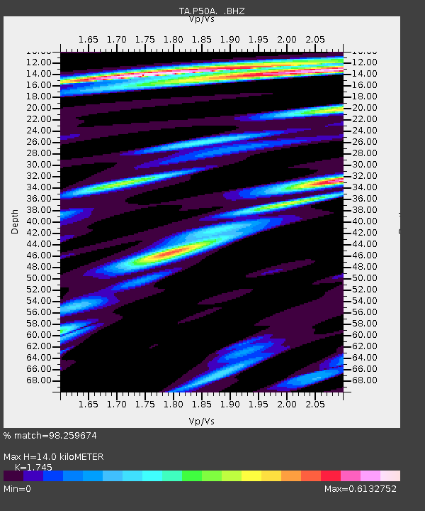
P50A Jamestown, OH, USA - Earthquake Result Viewer
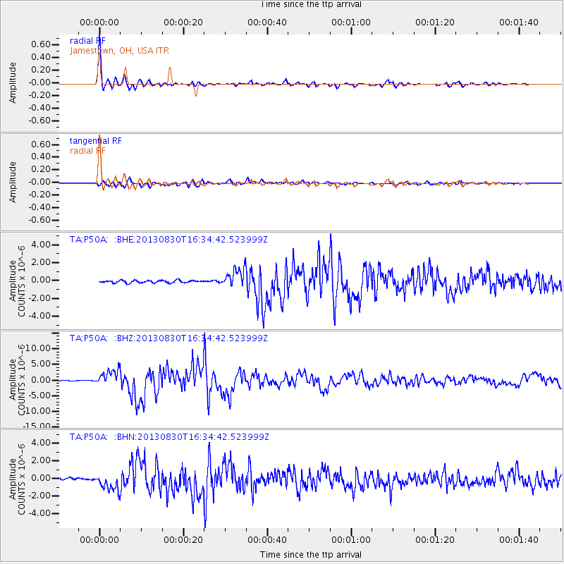
Earthquake location: Andreanof Islands, Aleutian Is.
Earthquake latitude/longitude: 51.5/-175.2
Earthquake time(UTC): 2013/08/30 (242) 16:25:02 GMT
Earthquake Depth: 29 km
Earthquake Magnitude: 7.0 MWW, 6.5 ML, 6.8 MI, 6.9 MWC, 6.9 MWB, 7.0 MWW, 7.0 MI, 7.0 MWC
Earthquake Catalog/Contributor: NEIC PDE/NEIC COMCAT
Network: TA USArray Transportable Network (new EarthScope stations)
Station: P50A Jamestown, OH, USA
Lat/Lon: 39.61 N/83.80 W
Elevation: 318 m
Distance: 61.1 deg
Az: 61.94 deg
Baz: 314.483 deg
Ray Param: 0.061073918
Estimated Moho Depth: 14.0 km
Estimated Crust Vp/Vs: 1.75
Assumed Crust Vp: 6.232 km/s
Estimated Crust Vs: 3.571 km/s
Estimated Crust Poisson's Ratio: 0.26
Radial Match: 98.259674 %
Radial Bump: 306
Transverse Match: 80.64843 %
Transverse Bump: 400
SOD ConfigId: 626651
Insert Time: 2014-04-18 05:24:50.854 +0000
GWidth: 2.5
Max Bumps: 400
Tol: 0.001

Signal To Noise

ChannelStoNSTALTA
TA:P50A: :BHZ:20130830T16:34:42.523999Z26.9239032.5614918E-69.5138205E-8
TA:P50A: :BHN:20130830T16:34:42.523999Z5.211339.633345E-71.8485387E-7
TA:P50A: :BHE:20130830T16:34:42.523999Z8.0229661.0388006E-61.2947837E-7
Arrivals
Ps1.7 SECOND
PpPs5.9 SECOND
PsPs/PpSs7.7 SECOND