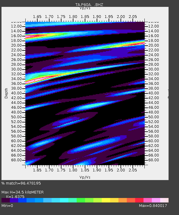
P60A Greenville, DE, USA - Earthquake Result Viewer

Earthquake location: Andreanof Islands, Aleutian Is.
Earthquake latitude/longitude: 51.5/-175.2
Earthquake time(UTC): 2013/08/30 (242) 16:25:02 GMT
Earthquake Depth: 29 km
Earthquake Magnitude: 7.0 MWW, 6.5 ML, 6.8 MI, 6.9 MWC, 6.9 MWB, 7.0 MWW, 7.0 MI, 7.0 MWC
Earthquake Catalog/Contributor: NEIC PDE/NEIC COMCAT
Network: TA USArray Transportable Network (new EarthScope stations)
Station: P60A Greenville, DE, USA
Lat/Lon: 39.81 N/75.64 W
Elevation: 105 m
Distance: 65.3 deg
Az: 56.718 deg
Baz: 317.324 deg
Ray Param: 0.058318987
Estimated Moho Depth: 34.5 km
Estimated Crust Vp/Vs: 1.64
Assumed Crust Vp: 6.287 km/s
Estimated Crust Vs: 3.84 km/s
Estimated Crust Poisson's Ratio: 0.20
Radial Match: 96.478195 %
Radial Bump: 400
Transverse Match: 79.43099 %
Transverse Bump: 400
SOD ConfigId: 626651
Insert Time: 2014-04-18 05:25:14.327 +0000
GWidth: 2.5
Max Bumps: 400
Tol: 0.001

Signal To Noise

ChannelStoNSTALTA
TA:P60A: :BHZ:20130830T16:35:10.575024Z18.9292052.2706581E-61.1995527E-7
TA:P60A: :BHN:20130830T16:35:10.575024Z7.1354817.333833E-71.02779794E-7
TA:P60A: :BHE:20130830T16:35:10.575024Z3.70037876.3520076E-71.716583E-7
Arrivals
Ps3.7 SECOND
PpPs14 SECOND
PsPs/PpSs18 SECOND