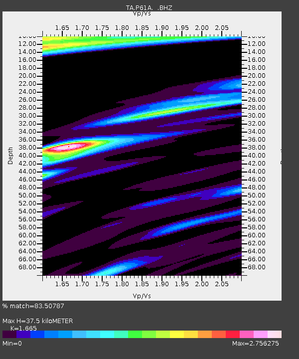
P61A Hammonton, NJ, USA - Earthquake Result Viewer
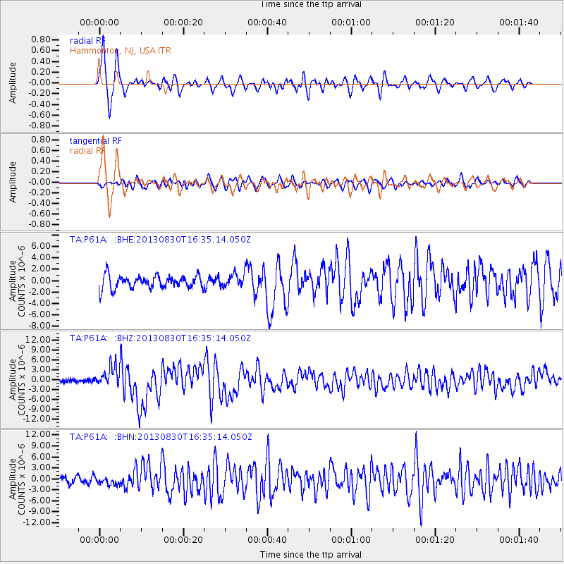
Earthquake location: Andreanof Islands, Aleutian Is.
Earthquake latitude/longitude: 51.5/-175.2
Earthquake time(UTC): 2013/08/30 (242) 16:25:02 GMT
Earthquake Depth: 29 km
Earthquake Magnitude: 7.0 MWW, 6.5 ML, 6.8 MI, 6.9 MWC, 6.9 MWB, 7.0 MWW, 7.0 MI, 7.0 MWC
Earthquake Catalog/Contributor: NEIC PDE/NEIC COMCAT
Network: TA USArray Transportable Network (new EarthScope stations)
Station: P61A Hammonton, NJ, USA
Lat/Lon: 39.67 N/74.79 W
Elevation: 22 m
Distance: 65.8 deg
Az: 56.293 deg
Baz: 317.686 deg
Ray Param: 0.057963915
Estimated Moho Depth: 37.5 km
Estimated Crust Vp/Vs: 1.66
Assumed Crust Vp: 6.287 km/s
Estimated Crust Vs: 3.776 km/s
Estimated Crust Poisson's Ratio: 0.22
Radial Match: 83.50787 %
Radial Bump: 400
Transverse Match: 61.36754 %
Transverse Bump: 400
SOD ConfigId: 626651
Insert Time: 2014-04-18 05:25:14.801 +0000
GWidth: 2.5
Max Bumps: 400
Tol: 0.001

Signal To Noise

ChannelStoNSTALTA
TA:P61A: :BHZ:20130830T16:35:14.050Z5.44237763.0170697E-65.543661E-7
TA:P61A: :BHN:20130830T16:35:14.050Z0.822198579.973829E-71.2130681E-6
TA:P61A: :BHE:20130830T16:35:14.050Z1.09855691.2470994E-61.135216E-6
Arrivals
Ps4.1 SECOND
PpPs15 SECOND
PsPs/PpSs19 SECOND