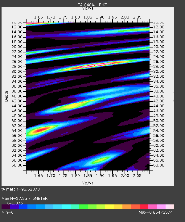
Q48A North Vernon, IN, USA - Earthquake Result Viewer
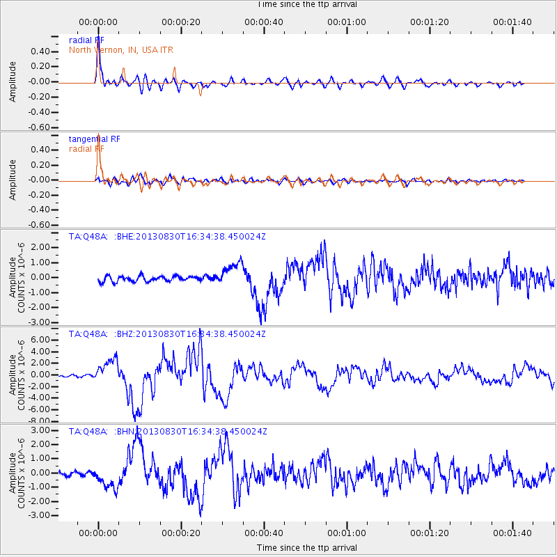
Earthquake location: Andreanof Islands, Aleutian Is.
Earthquake latitude/longitude: 51.5/-175.2
Earthquake time(UTC): 2013/08/30 (242) 16:25:02 GMT
Earthquake Depth: 29 km
Earthquake Magnitude: 7.0 MWW, 6.5 ML, 6.8 MI, 6.9 MWC, 6.9 MWB, 7.0 MWW, 7.0 MI, 7.0 MWC
Earthquake Catalog/Contributor: NEIC PDE/NEIC COMCAT
Network: TA USArray Transportable Network (new EarthScope stations)
Station: Q48A North Vernon, IN, USA
Lat/Lon: 38.93 N/85.73 W
Elevation: 185 m
Distance: 60.5 deg
Az: 63.697 deg
Baz: 314.123 deg
Ray Param: 0.061470225
Estimated Moho Depth: 27.25 km
Estimated Crust Vp/Vs: 1.88
Assumed Crust Vp: 6.498 km/s
Estimated Crust Vs: 3.465 km/s
Estimated Crust Poisson's Ratio: 0.30
Radial Match: 95.52873 %
Radial Bump: 400
Transverse Match: 86.27251 %
Transverse Bump: 400
SOD ConfigId: 626651
Insert Time: 2014-04-18 05:25:19.374 +0000
GWidth: 2.5
Max Bumps: 400
Tol: 0.001

Signal To Noise

ChannelStoNSTALTA
TA:Q48A: :BHZ:20130830T16:34:38.450024Z12.3008782.1652768E-61.760262E-7
TA:Q48A: :BHN:20130830T16:34:38.450024Z4.1719618.1448326E-71.9522794E-7
TA:Q48A: :BHE:20130830T16:34:38.450024Z4.6160828.2246345E-71.781735E-7
Arrivals
Ps3.8 SECOND
PpPs12 SECOND
PsPs/PpSs15 SECOND