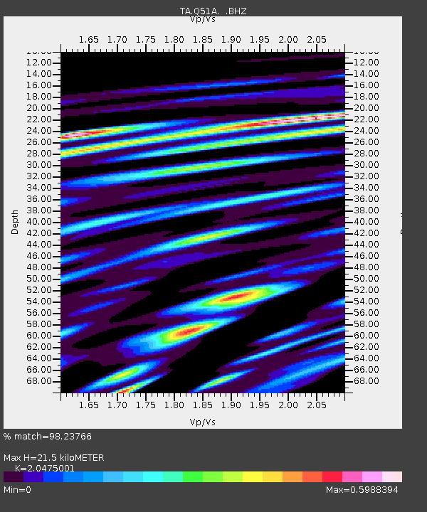
Q51A Peebles, OH, USA - Earthquake Result Viewer
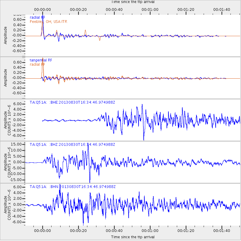
Earthquake location: Andreanof Islands, Aleutian Is.
Earthquake latitude/longitude: 51.5/-175.2
Earthquake time(UTC): 2013/08/30 (242) 16:25:02 GMT
Earthquake Depth: 29 km
Earthquake Magnitude: 7.0 MWW, 6.5 ML, 6.8 MI, 6.9 MWC, 6.9 MWB, 7.0 MWW, 7.0 MI, 7.0 MWC
Earthquake Catalog/Contributor: NEIC PDE/NEIC COMCAT
Network: TA USArray Transportable Network (new EarthScope stations)
Station: Q51A Peebles, OH, USA
Lat/Lon: 39.03 N/83.35 W
Elevation: 362 m
Distance: 61.7 deg
Az: 62.13 deg
Baz: 314.86 deg
Ray Param: 0.060650114
Estimated Moho Depth: 21.5 km
Estimated Crust Vp/Vs: 2.05
Assumed Crust Vp: 6.232 km/s
Estimated Crust Vs: 3.044 km/s
Estimated Crust Poisson's Ratio: 0.34
Radial Match: 98.23766 %
Radial Bump: 377
Transverse Match: 89.19604 %
Transverse Bump: 400
SOD ConfigId: 626651
Insert Time: 2014-04-18 05:25:28.337 +0000
GWidth: 2.5
Max Bumps: 400
Tol: 0.001

Signal To Noise

ChannelStoNSTALTA
TA:Q51A: :BHZ:20130830T16:34:46.974988Z17.7883632.3641758E-61.3290575E-7
TA:Q51A: :BHN:20130830T16:34:46.974988Z6.01656688.822709E-71.4664026E-7
TA:Q51A: :BHE:20130830T16:34:46.974988Z5.9067748.790645E-71.488231E-7
Arrivals
Ps3.7 SECOND
PpPs10 SECOND
PsPs/PpSs14 SECOND