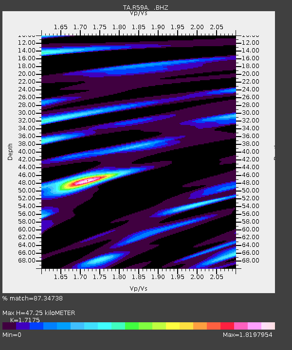
R59A King George, VA, USA - Earthquake Result Viewer
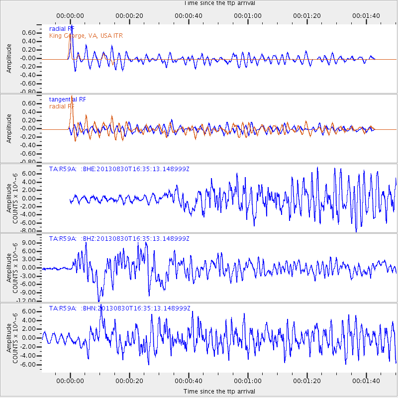
Earthquake location: Andreanof Islands, Aleutian Is.
Earthquake latitude/longitude: 51.5/-175.2
Earthquake time(UTC): 2013/08/30 (242) 16:25:02 GMT
Earthquake Depth: 29 km
Earthquake Magnitude: 7.0 MWW, 6.5 ML, 6.8 MI, 6.9 MWC, 6.9 MWB, 7.0 MWW, 7.0 MI, 7.0 MWC
Earthquake Catalog/Contributor: NEIC PDE/NEIC COMCAT
Network: TA USArray Transportable Network (new EarthScope stations)
Station: R59A King George, VA, USA
Lat/Lon: 38.20 N/77.12 W
Elevation: 35 m
Distance: 65.7 deg
Az: 58.848 deg
Baz: 317.28 deg
Ray Param: 0.058056384
Estimated Moho Depth: 47.25 km
Estimated Crust Vp/Vs: 1.72
Assumed Crust Vp: 6.419 km/s
Estimated Crust Vs: 3.738 km/s
Estimated Crust Poisson's Ratio: 0.24
Radial Match: 87.34738 %
Radial Bump: 400
Transverse Match: 72.93987 %
Transverse Bump: 400
SOD ConfigId: 626651
Insert Time: 2014-04-18 05:26:20.917 +0000
GWidth: 2.5
Max Bumps: 400
Tol: 0.001

Signal To Noise

ChannelStoNSTALTA
TA:R59A: :BHZ:20130830T16:35:13.148999Z12.50233652.598169E-62.0781468E-7
TA:R59A: :BHN:20130830T16:35:13.148999Z1.58903521.0372903E-66.5277993E-7
TA:R59A: :BHE:20130830T16:35:13.148999Z1.80308669.832293E-75.4530335E-7
Arrivals
Ps5.5 SECOND
PpPs19 SECOND
PsPs/PpSs25 SECOND