R60A Leonardtown, MD, USA - Earthquake Result Viewer
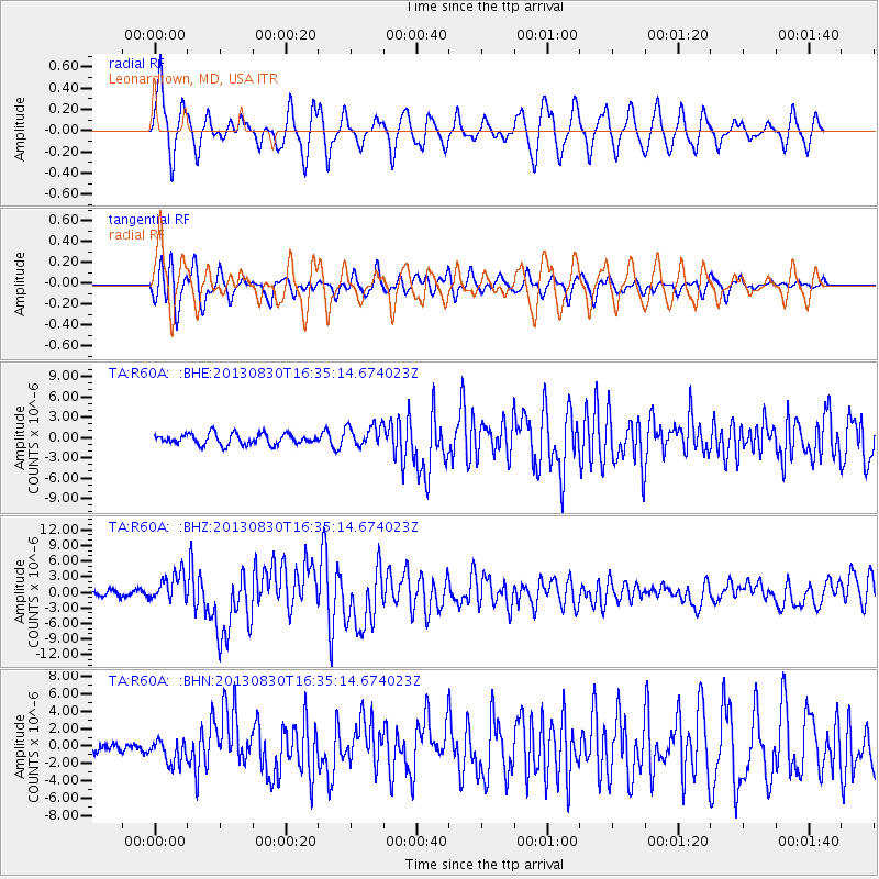
Earthquake location: Andreanof Islands, Aleutian Is.
Earthquake latitude/longitude: 51.5/-175.2
Earthquake time(UTC): 2013/08/30 (242) 16:25:02 GMT
Earthquake Depth: 29 km
Earthquake Magnitude: 7.0 MWW, 6.5 ML, 6.8 MI, 6.9 MWC, 6.9 MWB, 7.0 MWW, 7.0 MI, 7.0 MWC
Earthquake Catalog/Contributor: NEIC PDE/NEIC COMCAT
Network: TA USArray Transportable Network (new EarthScope stations)
Station: R60A Leonardtown, MD, USA
Lat/Lon: 38.26 N/76.58 W
Elevation: 33 m
Distance: 65.9 deg
Az: 58.461 deg
Baz: 317.451 deg
Ray Param: 0.057899836
Estimated Moho Depth: 25.5 km
Estimated Crust Vp/Vs: 2.05
Assumed Crust Vp: 6.419 km/s
Estimated Crust Vs: 3.131 km/s
Estimated Crust Poisson's Ratio: 0.34
Radial Match: 85.937195 %
Radial Bump: 400
Transverse Match: 71.202484 %
Transverse Bump: 400
SOD ConfigId: 626651
Insert Time: 2014-04-18 05:26:24.527 +0000
GWidth: 2.5
Max Bumps: 400
Tol: 0.001

Signal To Noise

ChannelStoNSTALTA
TA:R60A: :BHZ:20130830T16:35:14.674023Z6.91873172.7589479E-63.9876497E-7
TA:R60A: :BHN:20130830T16:35:14.674023Z2.09176781.3908312E-66.649071E-7
TA:R60A: :BHE:20130830T16:35:14.674023Z2.0330651.6300023E-68.0174624E-7
Arrivals
Ps4.3 SECOND
PpPs12 SECOND
PsPs/PpSs16 SECOND