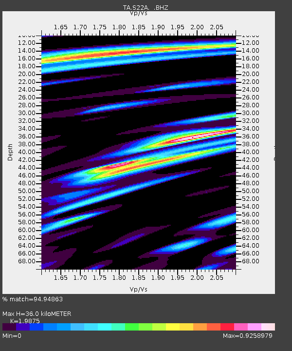
S22A 4UR Ranch, Creede, CO, USA - Earthquake Result Viewer

Earthquake location: Andreanof Islands, Aleutian Is.
Earthquake latitude/longitude: 51.5/-175.2
Earthquake time(UTC): 2013/08/30 (242) 16:25:02 GMT
Earthquake Depth: 29 km
Earthquake Magnitude: 7.0 MWW, 6.5 ML, 6.8 MI, 6.9 MWC, 6.9 MWB, 7.0 MWW, 7.0 MI, 7.0 MWC
Earthquake Catalog/Contributor: NEIC PDE/NEIC COMCAT
Network: TA USArray Transportable Network (new EarthScope stations)
Station: S22A 4UR Ranch, Creede, CO, USA
Lat/Lon: 37.75 N/106.83 W
Elevation: 2626 m
Distance: 48.8 deg
Az: 78.285 deg
Baz: 309.514 deg
Ray Param: 0.069047965
Estimated Moho Depth: 36.0 km
Estimated Crust Vp/Vs: 1.99
Assumed Crust Vp: 6.159 km/s
Estimated Crust Vs: 3.099 km/s
Estimated Crust Poisson's Ratio: 0.33
Radial Match: 94.94863 %
Radial Bump: 400
Transverse Match: 80.54127 %
Transverse Bump: 400
SOD ConfigId: 626651
Insert Time: 2014-04-18 05:26:28.920 +0000
GWidth: 2.5
Max Bumps: 400
Tol: 0.001

Signal To Noise

ChannelStoNSTALTA
TA:S22A: :BHZ:20130830T16:33:14.250012Z13.8139319.818973E-77.108022E-8
TA:S22A: :BHN:20130830T16:33:14.250012Z6.98392063.3349494E-74.7751826E-8
TA:S22A: :BHE:20130830T16:33:14.250012Z8.0528464.643897E-75.7667773E-8
Arrivals
Ps6.1 SECOND
PpPs17 SECOND
PsPs/PpSs23 SECOND