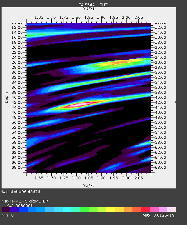
S54A Dingess, Beckley, WV, USA - Earthquake Result Viewer
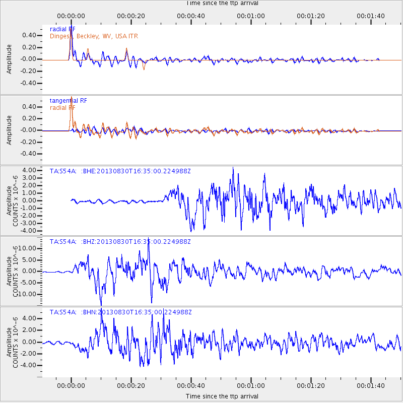
Earthquake location: Andreanof Islands, Aleutian Is.
Earthquake latitude/longitude: 51.5/-175.2
Earthquake time(UTC): 2013/08/30 (242) 16:25:02 GMT
Earthquake Depth: 29 km
Earthquake Magnitude: 7.0 MWW, 6.5 ML, 6.8 MI, 6.9 MWC, 6.9 MWB, 7.0 MWW, 7.0 MI, 7.0 MWC
Earthquake Catalog/Contributor: NEIC PDE/NEIC COMCAT
Network: TA USArray Transportable Network (new EarthScope stations)
Station: S54A Dingess, Beckley, WV, USA
Lat/Lon: 37.80 N/81.31 W
Elevation: 636 m
Distance: 63.7 deg
Az: 61.816 deg
Baz: 315.975 deg
Ray Param: 0.059352987
Estimated Moho Depth: 42.75 km
Estimated Crust Vp/Vs: 1.81
Assumed Crust Vp: 6.159 km/s
Estimated Crust Vs: 3.412 km/s
Estimated Crust Poisson's Ratio: 0.28
Radial Match: 96.43676 %
Radial Bump: 388
Transverse Match: 88.1826 %
Transverse Bump: 400
SOD ConfigId: 626651
Insert Time: 2014-04-18 05:26:44.736 +0000
GWidth: 2.5
Max Bumps: 400
Tol: 0.001

Signal To Noise

ChannelStoNSTALTA
TA:S54A: :BHZ:20130830T16:35:00.224988Z11.470032.3911257E-62.0846726E-7
TA:S54A: :BHN:20130830T16:35:00.224988Z4.0660798.3646853E-72.0571872E-7
TA:S54A: :BHE:20130830T16:35:00.224988Z5.46542177.961312E-71.4566693E-7
Arrivals
Ps5.8 SECOND
PpPs19 SECOND
PsPs/PpSs25 SECOND