T47A Sharon Grove, KY, USA - Earthquake Result Viewer
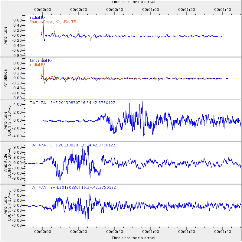
Earthquake location: Andreanof Islands, Aleutian Is.
Earthquake latitude/longitude: 51.5/-175.2
Earthquake time(UTC): 2013/08/30 (242) 16:25:02 GMT
Earthquake Depth: 29 km
Earthquake Magnitude: 7.0 MWW, 6.5 ML, 6.8 MI, 6.9 MWC, 6.9 MWB, 7.0 MWW, 7.0 MI, 7.0 MWC
Earthquake Catalog/Contributor: NEIC PDE/NEIC COMCAT
Network: TA USArray Transportable Network (new EarthScope stations)
Station: T47A Sharon Grove, KY, USA
Lat/Lon: 36.99 N/87.11 W
Elevation: 217 m
Distance: 61.0 deg
Az: 66.156 deg
Baz: 314.483 deg
Ray Param: 0.061089523
Estimated Moho Depth: 35.75 km
Estimated Crust Vp/Vs: 1.91
Assumed Crust Vp: 6.444 km/s
Estimated Crust Vs: 3.365 km/s
Estimated Crust Poisson's Ratio: 0.31
Radial Match: 98.249214 %
Radial Bump: 352
Transverse Match: 92.52259 %
Transverse Bump: 400
SOD ConfigId: 626651
Insert Time: 2014-04-18 05:27:13.299 +0000
GWidth: 2.5
Max Bumps: 400
Tol: 0.001

Signal To Noise

ChannelStoNSTALTA
TA:T47A: :BHZ:20130830T16:34:42.375012Z15.9570812.1303756E-61.335066E-7
TA:T47A: :BHN:20130830T16:34:42.375012Z5.6044788.905101E-71.5889259E-7
TA:T47A: :BHE:20130830T16:34:42.375012Z7.00978478.5617785E-71.2214039E-7
Arrivals
Ps5.3 SECOND
PpPs15 SECOND
PsPs/PpSs21 SECOND