You are here: Home > Network List > TA - USArray Transportable Network (new EarthScope stations) Stations List
> Station KSCO Kaye Shedlock's, Cheyenne Wells, CO, USA > Earthquake Result Viewer
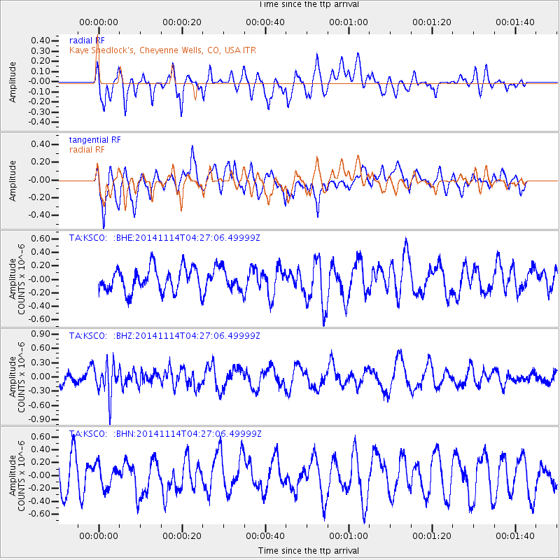
KSCO Kaye Shedlock's, Cheyenne Wells, CO, USA - Earthquake Result Viewer
*The percent match for this event was below the threshold and hence no stack was calculated.
| Earthquake location: |
Kuril Islands |
| Earthquake latitude/longitude: |
45.2/150.9 |
| Earthquake time(UTC): |
2014/11/14 (318) 04:16:07 GMT |
| Earthquake Depth: |
18 km |
| Earthquake Magnitude: |
5.7 MB |
| Earthquake Catalog/Contributor: |
NEIC PDE/NEIC COMCAT |
|
| Network: |
TA USArray Transportable Network (new EarthScope stations) |
| Station: |
KSCO Kaye Shedlock's, Cheyenne Wells, CO, USA |
| Lat/Lon: |
39.01 N/102.63 W |
| Elevation: |
1382 m |
|
| Distance: |
73.3 deg |
| Az: |
51.279 deg |
| Baz: |
314.941 deg |
| Ray Param: |
$rayparam |
*The percent match for this event was below the threshold and hence was not used in the summary stack. |
|
| Radial Match: |
43.605816 % |
| Radial Bump: |
400 |
| Transverse Match: |
61.376556 % |
| Transverse Bump: |
400 |
| SOD ConfigId: |
3390531 |
| Insert Time: |
2019-04-14 23:47:45.738 +0000 |
| GWidth: |
2.5 |
| Max Bumps: |
400 |
| Tol: |
0.001 |
|
Signal To Noise
| Channel | StoN | STA | LTA |
| TA:KSCO: :BHZ:20141114T04:27:06.49999Z | 2.037243 | 3.277156E-7 | 1.6086231E-7 |
| TA:KSCO: :BHN:20141114T04:27:06.49999Z | 0.6519893 | 1.7530911E-7 | 2.6888344E-7 |
| TA:KSCO: :BHE:20141114T04:27:06.49999Z | 0.8964757 | 1.5848497E-7 | 1.767867E-7 |
| Arrivals |
| Ps | |
| PpPs | |
| PsPs/PpSs | |


