You are here: Home > Network List > TA - USArray Transportable Network (new EarthScope stations) Stations List
> Station O48A Farmland, IN, USA > Earthquake Result Viewer
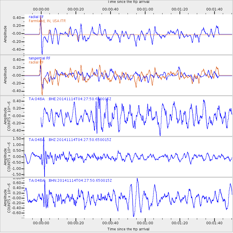
O48A Farmland, IN, USA - Earthquake Result Viewer
*The percent match for this event was below the threshold and hence no stack was calculated.
| Earthquake location: |
Kuril Islands |
| Earthquake latitude/longitude: |
45.2/150.9 |
| Earthquake time(UTC): |
2014/11/14 (318) 04:16:07 GMT |
| Earthquake Depth: |
18 km |
| Earthquake Magnitude: |
5.7 MB |
| Earthquake Catalog/Contributor: |
NEIC PDE/NEIC COMCAT |
|
| Network: |
TA USArray Transportable Network (new EarthScope stations) |
| Station: |
O48A Farmland, IN, USA |
| Lat/Lon: |
40.26 N/85.16 W |
| Elevation: |
300 m |
|
| Distance: |
81.2 deg |
| Az: |
39.996 deg |
| Baz: |
323.585 deg |
| Ray Param: |
$rayparam |
*The percent match for this event was below the threshold and hence was not used in the summary stack. |
|
| Radial Match: |
67.19144 % |
| Radial Bump: |
400 |
| Transverse Match: |
70.46336 % |
| Transverse Bump: |
400 |
| SOD ConfigId: |
3390531 |
| Insert Time: |
2019-04-14 23:47:53.490 +0000 |
| GWidth: |
2.5 |
| Max Bumps: |
400 |
| Tol: |
0.001 |
|
Signal To Noise
| Channel | StoN | STA | LTA |
| TA:O48A: :BHZ:20141114T04:27:50.650015Z | 2.3429735 | 5.537163E-7 | 2.3633059E-7 |
| TA:O48A: :BHN:20141114T04:27:50.650015Z | 1.1780087 | 2.4018692E-7 | 2.0389233E-7 |
| TA:O48A: :BHE:20141114T04:27:50.650015Z | 1.9376112 | 2.8304842E-7 | 1.4608112E-7 |
| Arrivals |
| Ps | |
| PpPs | |
| PsPs/PpSs | |


