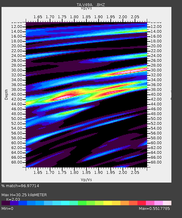
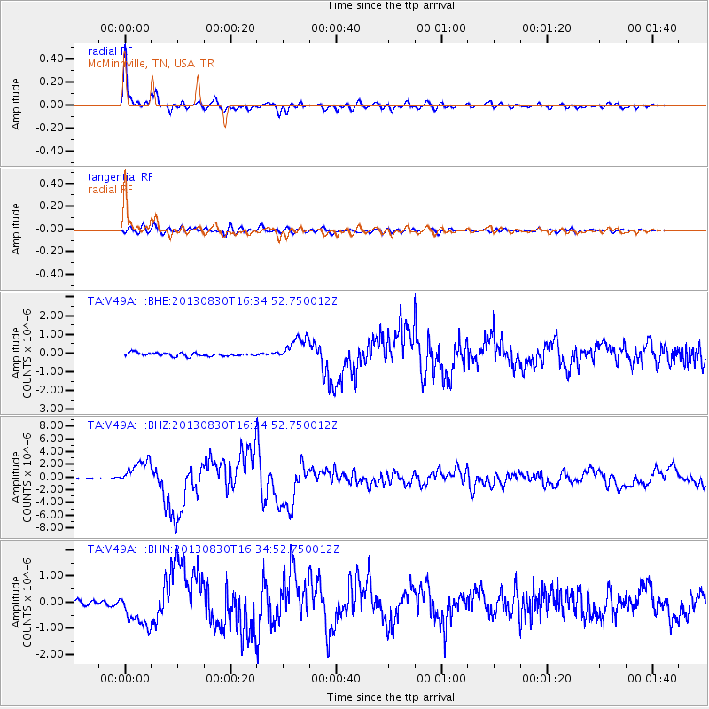
V49A McMinnville, TN, USA - Earthquake Result Viewer

Earthquake location: Andreanof Islands, Aleutian Is.
Earthquake latitude/longitude: 51.5/-175.2
Earthquake time(UTC): 2013/08/30 (242) 16:25:02 GMT
Earthquake Depth: 29 km
Earthquake Magnitude: 7.0 MWW, 6.5 ML, 6.8 MI, 6.9 MWC, 6.9 MWB, 7.0 MWW, 7.0 MI, 7.0 MWC
Earthquake Catalog/Contributor: NEIC PDE/NEIC COMCAT
Network: TA USArray Transportable Network (new EarthScope stations)
Station: V49A McMinnville, TN, USA
Lat/Lon: 35.77 N/85.90 W
Elevation: 329 m
Distance: 62.6 deg
Az: 66.359 deg
Baz: 315.289 deg
Ray Param: 0.06008429
Estimated Moho Depth: 30.25 km
Estimated Crust Vp/Vs: 2.03
Assumed Crust Vp: 6.35 km/s
Estimated Crust Vs: 3.128 km/s
Estimated Crust Poisson's Ratio: 0.34
Radial Match: 96.97714 %
Radial Bump: 400
Transverse Match: 84.22642 %
Transverse Bump: 400
SOD ConfigId: 626651
Insert Time: 2014-04-18 05:28:32.384 +0000
GWidth: 2.5
Max Bumps: 400
Tol: 0.001

Signal To Noise

ChannelStoNSTALTA
TA:V49A: :BHZ:20130830T16:34:52.750012Z20.5168632.0328375E-69.90813E-8
TA:V49A: :BHN:20130830T16:34:52.750012Z6.42107257.109498E-71.10721345E-7
TA:V49A: :BHE:20130830T16:34:52.750012Z7.5369856.5869085E-78.7394476E-8
Arrivals
Ps5.1 SECOND
PpPs14 SECOND
PsPs/PpSs19 SECOND