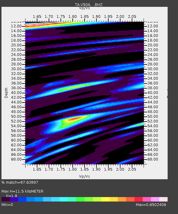
V50A Pikevile, TN, USA - Earthquake Result Viewer
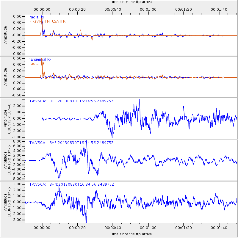
Earthquake location: Andreanof Islands, Aleutian Is.
Earthquake latitude/longitude: 51.5/-175.2
Earthquake time(UTC): 2013/08/30 (242) 16:25:02 GMT
Earthquake Depth: 29 km
Earthquake Magnitude: 7.0 MWW, 6.5 ML, 6.8 MI, 6.9 MWC, 6.9 MWB, 7.0 MWW, 7.0 MI, 7.0 MWC
Earthquake Catalog/Contributor: NEIC PDE/NEIC COMCAT
Network: TA USArray Transportable Network (new EarthScope stations)
Station: V50A Pikevile, TN, USA
Lat/Lon: 35.67 N/85.10 W
Elevation: 287 m
Distance: 63.1 deg
Az: 65.911 deg
Baz: 315.551 deg
Ray Param: 0.059743874
Estimated Moho Depth: 11.5 km
Estimated Crust Vp/Vs: 1.60
Assumed Crust Vp: 6.35 km/s
Estimated Crust Vs: 3.969 km/s
Estimated Crust Poisson's Ratio: 0.18
Radial Match: 97.63987 %
Radial Bump: 400
Transverse Match: 84.48388 %
Transverse Bump: 400
SOD ConfigId: 626651
Insert Time: 2014-04-18 05:28:37.496 +0000
GWidth: 2.5
Max Bumps: 400
Tol: 0.001

Signal To Noise

ChannelStoNSTALTA
TA:V50A: :BHZ:20130830T16:34:56.248975Z14.0680331.9996103E-61.4213859E-7
TA:V50A: :BHN:20130830T16:34:56.248975Z7.38266376.8471974E-79.274698E-8
TA:V50A: :BHE:20130830T16:34:56.248975Z7.8378727.262348E-79.265714E-8
Arrivals
Ps1.1 SECOND
PpPs4.5 SECOND
PsPs/PpSs5.6 SECOND