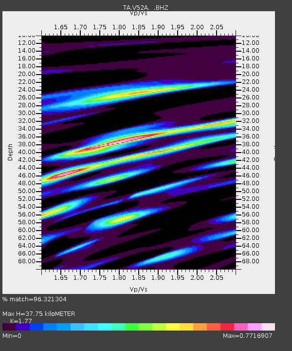
V52A Sevierville, TN, USA - Earthquake Result Viewer

Earthquake location: Andreanof Islands, Aleutian Is.
Earthquake latitude/longitude: 51.5/-175.2
Earthquake time(UTC): 2013/08/30 (242) 16:25:02 GMT
Earthquake Depth: 29 km
Earthquake Magnitude: 7.0 MWW, 6.5 ML, 6.8 MI, 6.9 MWC, 6.9 MWB, 7.0 MWW, 7.0 MI, 7.0 MWC
Earthquake Catalog/Contributor: NEIC PDE/NEIC COMCAT
Network: TA USArray Transportable Network (new EarthScope stations)
Station: V52A Sevierville, TN, USA
Lat/Lon: 35.84 N/83.60 W
Elevation: 328 m
Distance: 63.8 deg
Az: 64.799 deg
Baz: 315.93 deg
Ray Param: 0.059266876
Estimated Moho Depth: 37.75 km
Estimated Crust Vp/Vs: 1.77
Assumed Crust Vp: 6.35 km/s
Estimated Crust Vs: 3.588 km/s
Estimated Crust Poisson's Ratio: 0.27
Radial Match: 96.321304 %
Radial Bump: 400
Transverse Match: 81.862305 %
Transverse Bump: 400
SOD ConfigId: 626651
Insert Time: 2014-04-18 05:28:41.917 +0000
GWidth: 2.5
Max Bumps: 400
Tol: 0.001

Signal To Noise

ChannelStoNSTALTA
TA:V52A: :BHZ:20130830T16:35:01.075024Z12.3554982.1080352E-61.7061515E-7
TA:V52A: :BHN:20130830T16:35:01.075024Z5.5439446.8007E-71.2266898E-7
TA:V52A: :BHE:20130830T16:35:01.075024Z5.42902377.112218E-71.3100362E-7
Arrivals
Ps4.8 SECOND
PpPs16 SECOND
PsPs/PpSs21 SECOND