V53A Saluda, NC, USA - Earthquake Result Viewer
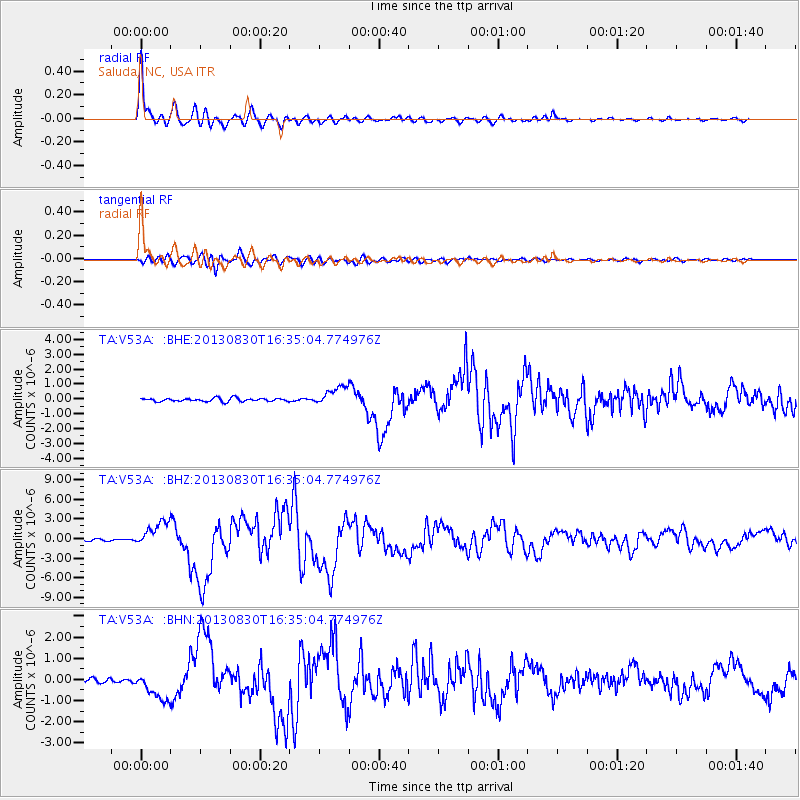
Earthquake location: Andreanof Islands, Aleutian Is.
Earthquake latitude/longitude: 51.5/-175.2
Earthquake time(UTC): 2013/08/30 (242) 16:25:02 GMT
Earthquake Depth: 29 km
Earthquake Magnitude: 7.0 MWW, 6.5 ML, 6.8 MI, 6.9 MWC, 6.9 MWB, 7.0 MWW, 7.0 MI, 7.0 MWC
Earthquake Catalog/Contributor: NEIC PDE/NEIC COMCAT
Network: TA USArray Transportable Network (new EarthScope stations)
Station: V53A Saluda, NC, USA
Lat/Lon: 35.67 N/82.81 W
Elevation: 681 m
Distance: 64.4 deg
Az: 64.422 deg
Baz: 316.221 deg
Ray Param: 0.058896866
Estimated Moho Depth: 44.75 km
Estimated Crust Vp/Vs: 1.72
Assumed Crust Vp: 6.35 km/s
Estimated Crust Vs: 3.692 km/s
Estimated Crust Poisson's Ratio: 0.24
Radial Match: 97.9904 %
Radial Bump: 392
Transverse Match: 88.03685 %
Transverse Bump: 400
SOD ConfigId: 626651
Insert Time: 2014-04-18 05:28:42.860 +0000
GWidth: 2.5
Max Bumps: 400
Tol: 0.001

Signal To Noise

ChannelStoNSTALTA
TA:V53A: :BHZ:20130830T16:35:04.774976Z14.2343491.9371562E-61.3609025E-7
TA:V53A: :BHN:20130830T16:35:04.774976Z6.5168816.632757E-71.017781E-7
TA:V53A: :BHE:20130830T16:35:04.774976Z5.58942846.2491375E-71.11802805E-7
Arrivals
Ps5.3 SECOND
PpPs18 SECOND
PsPs/PpSs24 SECOND