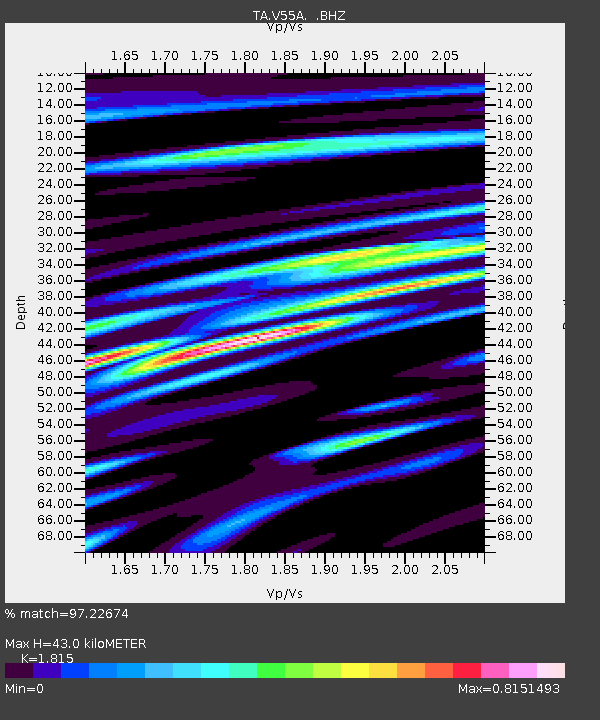
V55A Taylorsville, NC, USA - Earthquake Result Viewer
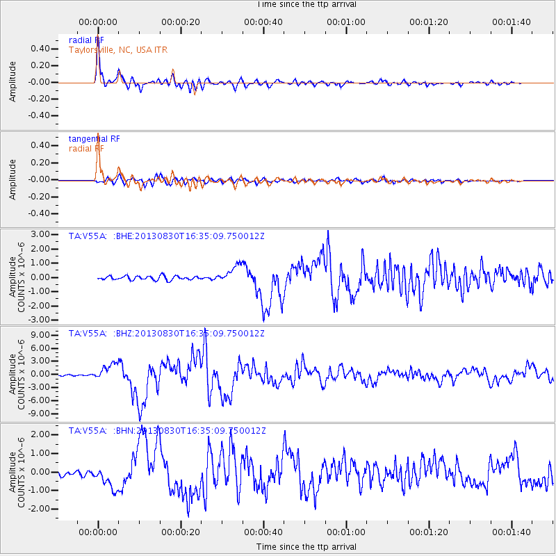
Earthquake location: Andreanof Islands, Aleutian Is.
Earthquake latitude/longitude: 51.5/-175.2
Earthquake time(UTC): 2013/08/30 (242) 16:25:02 GMT
Earthquake Depth: 29 km
Earthquake Magnitude: 7.0 MWW, 6.5 ML, 6.8 MI, 6.9 MWC, 6.9 MWB, 7.0 MWW, 7.0 MI, 7.0 MWC
Earthquake Catalog/Contributor: NEIC PDE/NEIC COMCAT
Network: TA USArray Transportable Network (new EarthScope stations)
Station: V55A Taylorsville, NC, USA
Lat/Lon: 35.85 N/81.21 W
Elevation: 306 m
Distance: 65.2 deg
Az: 63.242 deg
Baz: 316.648 deg
Ray Param: 0.058401845
Estimated Moho Depth: 43.0 km
Estimated Crust Vp/Vs: 1.82
Assumed Crust Vp: 6.419 km/s
Estimated Crust Vs: 3.537 km/s
Estimated Crust Poisson's Ratio: 0.28
Radial Match: 97.22674 %
Radial Bump: 400
Transverse Match: 90.16764 %
Transverse Bump: 400
SOD ConfigId: 626651
Insert Time: 2014-04-18 05:28:47.487 +0000
GWidth: 2.5
Max Bumps: 400
Tol: 0.001

Signal To Noise

ChannelStoNSTALTA
TA:V55A: :BHZ:20130830T16:35:09.750012Z11.9798811.9601648E-61.636214E-7
TA:V55A: :BHN:20130830T16:35:09.750012Z4.8025096.5709594E-71.3682346E-7
TA:V55A: :BHE:20130830T16:35:09.750012Z4.64216576.427723E-71.3846389E-7
Arrivals
Ps5.7 SECOND
PpPs18 SECOND
PsPs/PpSs24 SECOND