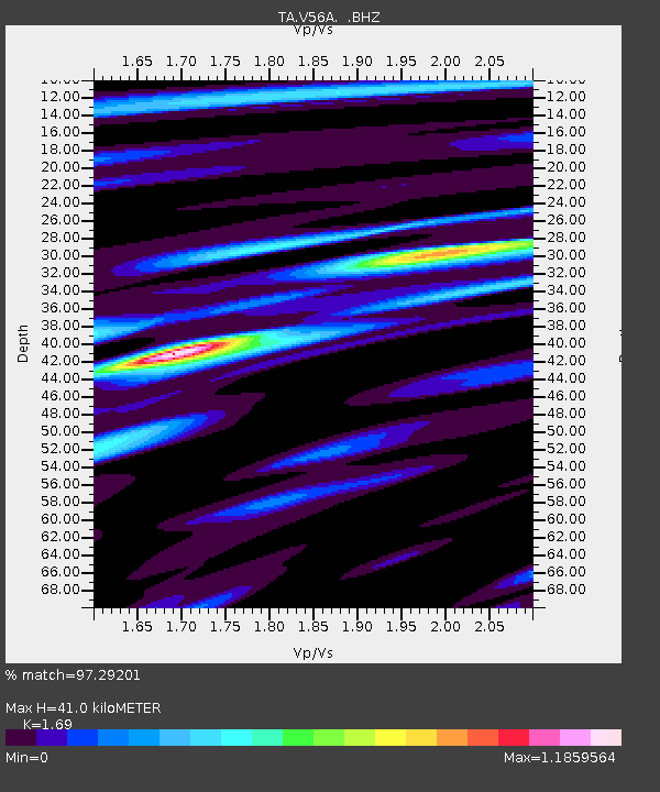
V56A Mocksville, NC, USA - Earthquake Result Viewer
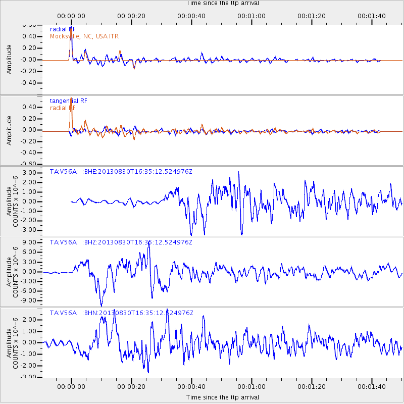
Earthquake location: Andreanof Islands, Aleutian Is.
Earthquake latitude/longitude: 51.5/-175.2
Earthquake time(UTC): 2013/08/30 (242) 16:25:02 GMT
Earthquake Depth: 29 km
Earthquake Magnitude: 7.0 MWW, 6.5 ML, 6.8 MI, 6.9 MWC, 6.9 MWB, 7.0 MWW, 7.0 MI, 7.0 MWC
Earthquake Catalog/Contributor: NEIC PDE/NEIC COMCAT
Network: TA USArray Transportable Network (new EarthScope stations)
Station: V56A Mocksville, NC, USA
Lat/Lon: 35.81 N/80.50 W
Elevation: 237 m
Distance: 65.6 deg
Az: 62.806 deg
Baz: 316.885 deg
Ray Param: 0.058119293
Estimated Moho Depth: 41.0 km
Estimated Crust Vp/Vs: 1.69
Assumed Crust Vp: 6.419 km/s
Estimated Crust Vs: 3.798 km/s
Estimated Crust Poisson's Ratio: 0.23
Radial Match: 97.29201 %
Radial Bump: 383
Transverse Match: 90.039375 %
Transverse Bump: 400
SOD ConfigId: 626651
Insert Time: 2014-04-18 05:28:51.215 +0000
GWidth: 2.5
Max Bumps: 400
Tol: 0.001

Signal To Noise

ChannelStoNSTALTA
TA:V56A: :BHZ:20130830T16:35:12.524976Z10.7643871.9460565E-61.8078654E-7
TA:V56A: :BHN:20130830T16:35:12.524976Z6.3954096.1761574E-79.657173E-8
TA:V56A: :BHE:20130830T16:35:12.524976Z3.67576866.5094923E-71.77092E-7
Arrivals
Ps4.6 SECOND
PpPs16 SECOND
PsPs/PpSs21 SECOND