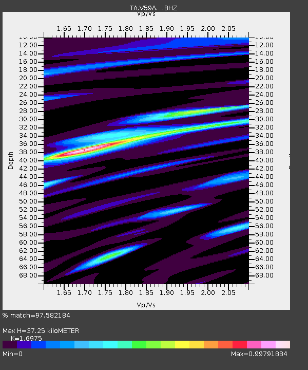
V59A Middlesex, NC, USA - Earthquake Result Viewer
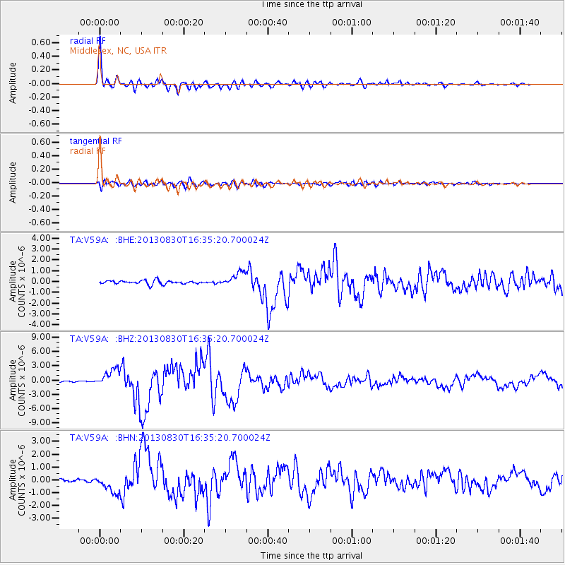
Earthquake location: Andreanof Islands, Aleutian Is.
Earthquake latitude/longitude: 51.5/-175.2
Earthquake time(UTC): 2013/08/30 (242) 16:25:02 GMT
Earthquake Depth: 29 km
Earthquake Magnitude: 7.0 MWW, 6.5 ML, 6.8 MI, 6.9 MWC, 6.9 MWB, 7.0 MWW, 7.0 MI, 7.0 MWC
Earthquake Catalog/Contributor: NEIC PDE/NEIC COMCAT
Network: TA USArray Transportable Network (new EarthScope stations)
Station: V59A Middlesex, NC, USA
Lat/Lon: 35.76 N/78.24 W
Elevation: 58 m
Distance: 66.9 deg
Az: 61.367 deg
Baz: 317.62 deg
Ray Param: 0.057277415
Estimated Moho Depth: 37.25 km
Estimated Crust Vp/Vs: 1.70
Assumed Crust Vp: 6.565 km/s
Estimated Crust Vs: 3.867 km/s
Estimated Crust Poisson's Ratio: 0.23
Radial Match: 97.582184 %
Radial Bump: 400
Transverse Match: 89.30278 %
Transverse Bump: 400
SOD ConfigId: 626651
Insert Time: 2014-04-18 05:28:56.444 +0000
GWidth: 2.5
Max Bumps: 400
Tol: 0.001

Signal To Noise

ChannelStoNSTALTA
TA:V59A: :BHZ:20130830T16:35:20.700024Z13.5671381.8603172E-61.3711936E-7
TA:V59A: :BHN:20130830T16:35:20.700024Z6.49987947.116718E-71.0949E-7
TA:V59A: :BHE:20130830T16:35:20.700024Z3.98471076.762907E-71.697214E-7
Arrivals
Ps4.1 SECOND
PpPs15 SECOND
PsPs/PpSs19 SECOND