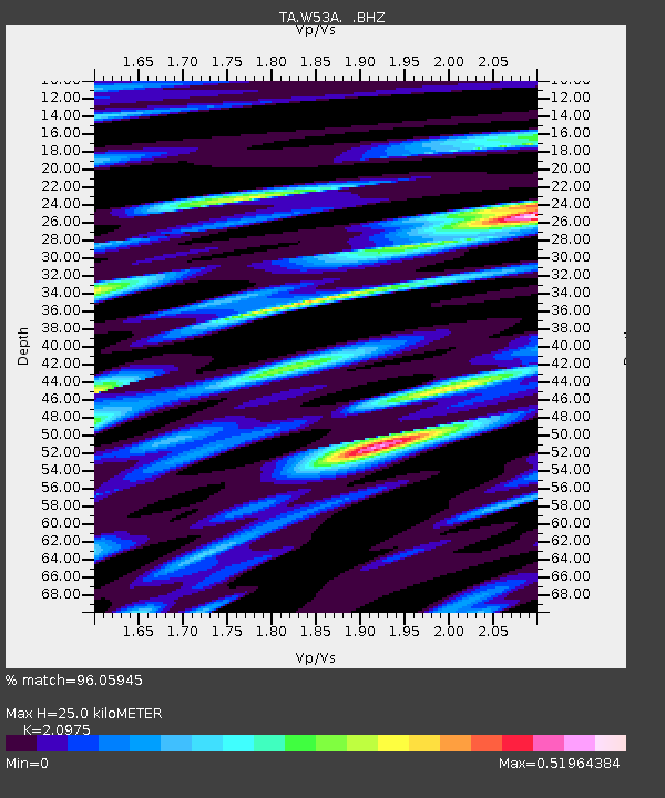
W53A Cullowhee, NC, USA - Earthquake Result Viewer
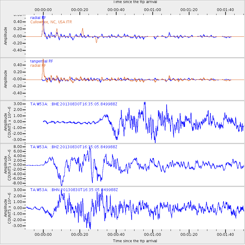
Earthquake location: Andreanof Islands, Aleutian Is.
Earthquake latitude/longitude: 51.5/-175.2
Earthquake time(UTC): 2013/08/30 (242) 16:25:02 GMT
Earthquake Depth: 29 km
Earthquake Magnitude: 7.0 MWW, 6.5 ML, 6.8 MI, 6.9 MWC, 6.9 MWB, 7.0 MWW, 7.0 MI, 7.0 MWC
Earthquake Catalog/Contributor: NEIC PDE/NEIC COMCAT
Network: TA USArray Transportable Network (new EarthScope stations)
Station: W53A Cullowhee, NC, USA
Lat/Lon: 35.17 N/83.16 W
Elevation: 1180 m
Distance: 64.6 deg
Az: 65.033 deg
Baz: 316.282 deg
Ray Param: 0.058793116
Estimated Moho Depth: 25.0 km
Estimated Crust Vp/Vs: 2.10
Assumed Crust Vp: 6.35 km/s
Estimated Crust Vs: 3.027 km/s
Estimated Crust Poisson's Ratio: 0.35
Radial Match: 96.05945 %
Radial Bump: 369
Transverse Match: 84.15156 %
Transverse Bump: 400
SOD ConfigId: 626651
Insert Time: 2014-04-18 05:29:25.031 +0000
GWidth: 2.5
Max Bumps: 400
Tol: 0.001

Signal To Noise

ChannelStoNSTALTA
TA:W53A: :BHZ:20130830T16:35:05.849988Z13.5582411.9460688E-61.4353401E-7
TA:W53A: :BHN:20130830T16:35:05.849988Z4.6112757.3631196E-71.5967643E-7
TA:W53A: :BHE:20130830T16:35:05.849988Z6.55830057.1923984E-71.09668626E-7
Arrivals
Ps4.5 SECOND
PpPs12 SECOND
PsPs/PpSs16 SECOND