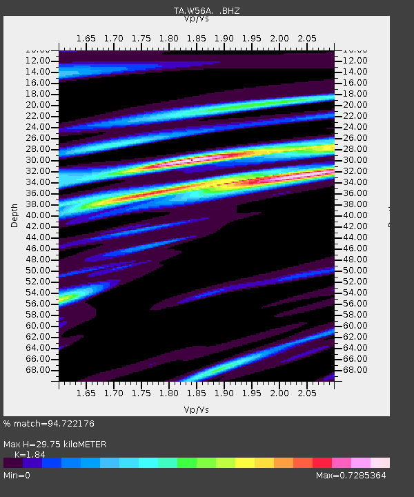
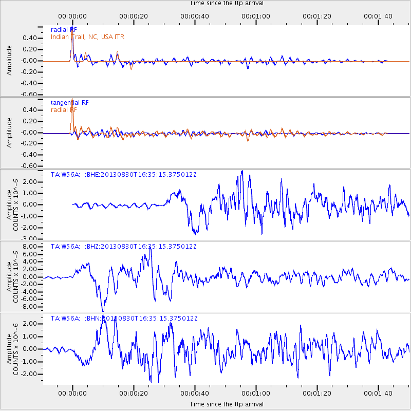
W56A Indian Trail, NC, USA - Earthquake Result Viewer

Earthquake location: Andreanof Islands, Aleutian Is.
Earthquake latitude/longitude: 51.5/-175.2
Earthquake time(UTC): 2013/08/30 (242) 16:25:02 GMT
Earthquake Depth: 29 km
Earthquake Magnitude: 7.0 MWW, 6.5 ML, 6.8 MI, 6.9 MWC, 6.9 MWB, 7.0 MWW, 7.0 MI, 7.0 MWC
Earthquake Catalog/Contributor: NEIC PDE/NEIC COMCAT
Network: TA USArray Transportable Network (new EarthScope stations)
Station: W56A Indian Trail, NC, USA
Lat/Lon: 35.13 N/80.58 W
Elevation: 177 m
Distance: 66.0 deg
Az: 63.366 deg
Baz: 317.065 deg
Ray Param: 0.057828393
Estimated Moho Depth: 29.75 km
Estimated Crust Vp/Vs: 1.84
Assumed Crust Vp: 6.419 km/s
Estimated Crust Vs: 3.489 km/s
Estimated Crust Poisson's Ratio: 0.29
Radial Match: 94.722176 %
Radial Bump: 400
Transverse Match: 83.587685 %
Transverse Bump: 400
SOD ConfigId: 626651
Insert Time: 2014-04-18 05:29:29.733 +0000
GWidth: 2.5
Max Bumps: 400
Tol: 0.001

Signal To Noise

ChannelStoNSTALTA
TA:W56A: :BHZ:20130830T16:35:15.375012Z15.0378732.0918526E-61.3910562E-7
TA:W56A: :BHN:20130830T16:35:15.375012Z5.30807457.512427E-71.4152829E-7
TA:W56A: :BHE:20130830T16:35:15.375012Z5.52172147.145578E-71.2940853E-7
Arrivals
Ps4.0 SECOND
PpPs13 SECOND
PsPs/PpSs17 SECOND