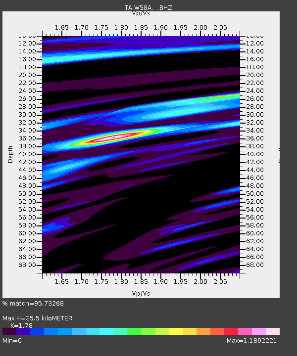
W58A Raeford, NC, USA - Earthquake Result Viewer

Earthquake location: Andreanof Islands, Aleutian Is.
Earthquake latitude/longitude: 51.5/-175.2
Earthquake time(UTC): 2013/08/30 (242) 16:25:02 GMT
Earthquake Depth: 29 km
Earthquake Magnitude: 7.0 MWW, 6.5 ML, 6.8 MI, 6.9 MWC, 6.9 MWB, 7.0 MWW, 7.0 MI, 7.0 MWC
Earthquake Catalog/Contributor: NEIC PDE/NEIC COMCAT
Network: TA USArray Transportable Network (new EarthScope stations)
Station: W58A Raeford, NC, USA
Lat/Lon: 35.02 N/79.23 W
Elevation: 84 m
Distance: 66.9 deg
Az: 62.563 deg
Baz: 317.516 deg
Ray Param: 0.057277374
Estimated Moho Depth: 35.5 km
Estimated Crust Vp/Vs: 1.78
Assumed Crust Vp: 6.565 km/s
Estimated Crust Vs: 3.688 km/s
Estimated Crust Poisson's Ratio: 0.27
Radial Match: 95.73268 %
Radial Bump: 400
Transverse Match: 86.92272 %
Transverse Bump: 400
SOD ConfigId: 626651
Insert Time: 2014-04-18 05:29:34.348 +0000
GWidth: 2.5
Max Bumps: 400
Tol: 0.001

Signal To Noise

ChannelStoNSTALTA
TA:W58A: :BHZ:20130830T16:35:20.698987Z11.1845862.0229295E-61.8086763E-7
TA:W58A: :BHN:20130830T16:35:20.698987Z6.08615977.436418E-71.2218571E-7
TA:W58A: :BHE:20130830T16:35:20.698987Z6.27091037.8721547E-71.2553448E-7
Arrivals
Ps4.4 SECOND
PpPs14 SECOND
PsPs/PpSs19 SECOND