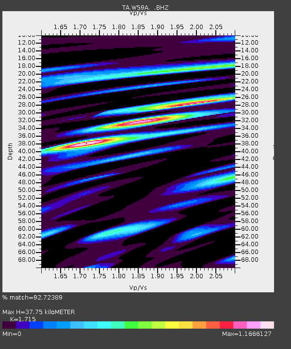
W59A Clinton, NC, USA - Earthquake Result Viewer
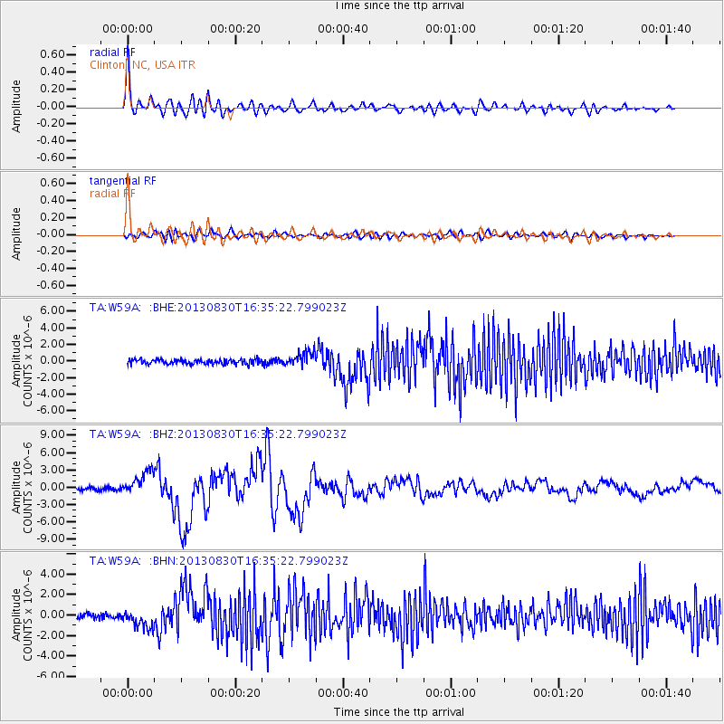
Earthquake location: Andreanof Islands, Aleutian Is.
Earthquake latitude/longitude: 51.5/-175.2
Earthquake time(UTC): 2013/08/30 (242) 16:25:02 GMT
Earthquake Depth: 29 km
Earthquake Magnitude: 7.0 MWW, 6.5 ML, 6.8 MI, 6.9 MWC, 6.9 MWB, 7.0 MWW, 7.0 MI, 7.0 MWC
Earthquake Catalog/Contributor: NEIC PDE/NEIC COMCAT
Network: TA USArray Transportable Network (new EarthScope stations)
Station: W59A Clinton, NC, USA
Lat/Lon: 35.17 N/78.44 W
Elevation: 60 m
Distance: 67.2 deg
Az: 61.937 deg
Baz: 317.724 deg
Ray Param: 0.05706185
Estimated Moho Depth: 37.75 km
Estimated Crust Vp/Vs: 1.72
Assumed Crust Vp: 6.565 km/s
Estimated Crust Vs: 3.828 km/s
Estimated Crust Poisson's Ratio: 0.24
Radial Match: 92.72389 %
Radial Bump: 400
Transverse Match: 63.977467 %
Transverse Bump: 400
SOD ConfigId: 626651
Insert Time: 2014-04-18 05:29:36.165 +0000
GWidth: 2.5
Max Bumps: 400
Tol: 0.001

Signal To Noise

ChannelStoNSTALTA
TA:W59A: :BHZ:20130830T16:35:22.799023Z8.6287862.0988455E-62.4323762E-7
TA:W59A: :BHN:20130830T16:35:22.799023Z2.9231639.1274785E-73.1224667E-7
TA:W59A: :BHE:20130830T16:35:22.799023Z3.05489528.7413287E-72.861417E-7
Arrivals
Ps4.3 SECOND
PpPs15 SECOND
PsPs/PpSs19 SECOND