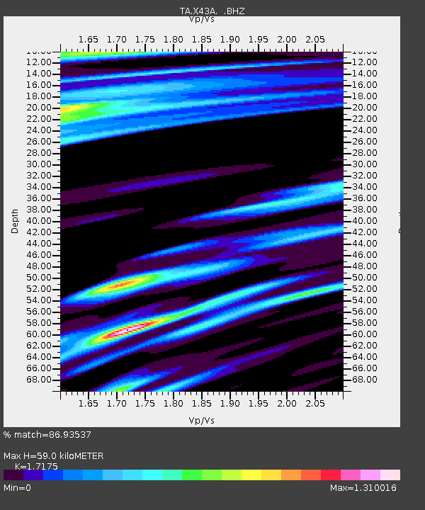
X43A Marvell, AR, USA - Earthquake Result Viewer

Earthquake location: Andreanof Islands, Aleutian Is.
Earthquake latitude/longitude: 51.5/-175.2
Earthquake time(UTC): 2013/08/30 (242) 16:25:02 GMT
Earthquake Depth: 29 km
Earthquake Magnitude: 7.0 MWW, 6.5 ML, 6.8 MI, 6.9 MWC, 6.9 MWB, 7.0 MWW, 7.0 MI, 7.0 MWC
Earthquake Catalog/Contributor: NEIC PDE/NEIC COMCAT
Network: TA USArray Transportable Network (new EarthScope stations)
Station: X43A Marvell, AR, USA
Lat/Lon: 34.52 N/90.88 W
Elevation: 53 m
Distance: 60.6 deg
Az: 70.635 deg
Baz: 314.471 deg
Ray Param: 0.06139705
Estimated Moho Depth: 59.0 km
Estimated Crust Vp/Vs: 1.72
Assumed Crust Vp: 6.273 km/s
Estimated Crust Vs: 3.653 km/s
Estimated Crust Poisson's Ratio: 0.24
Radial Match: 86.93537 %
Radial Bump: 400
Transverse Match: 73.41208 %
Transverse Bump: 400
SOD ConfigId: 626651
Insert Time: 2014-04-18 05:29:48.809 +0000
GWidth: 2.5
Max Bumps: 400
Tol: 0.001

Signal To Noise

ChannelStoNSTALTA
TA:X43A: :BHZ:20130830T16:34:39.224011Z4.06136852.1513927E-65.2972115E-7
TA:X43A: :BHN:20130830T16:34:39.224011Z1.61748589.952007E-76.152763E-7
TA:X43A: :BHE:20130830T16:34:39.224011Z1.47282478.7318955E-75.9286725E-7
Arrivals
Ps7.1 SECOND
PpPs24 SECOND
PsPs/PpSs31 SECOND