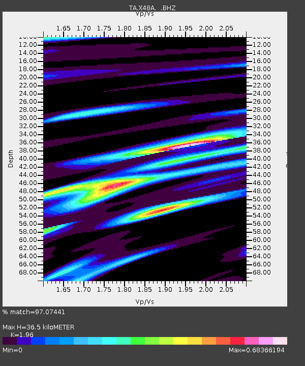
X48A Hartselle, AL, USA - Earthquake Result Viewer
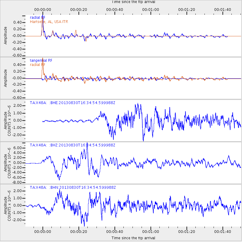
Earthquake location: Andreanof Islands, Aleutian Is.
Earthquake latitude/longitude: 51.5/-175.2
Earthquake time(UTC): 2013/08/30 (242) 16:25:02 GMT
Earthquake Depth: 29 km
Earthquake Magnitude: 7.0 MWW, 6.5 ML, 6.8 MI, 6.9 MWC, 6.9 MWB, 7.0 MWW, 7.0 MI, 7.0 MWC
Earthquake Catalog/Contributor: NEIC PDE/NEIC COMCAT
Network: TA USArray Transportable Network (new EarthScope stations)
Station: X48A Hartselle, AL, USA
Lat/Lon: 34.45 N/87.05 W
Elevation: 180 m
Distance: 62.9 deg
Az: 68.146 deg
Baz: 315.454 deg
Ray Param: 0.05990602
Estimated Moho Depth: 36.5 km
Estimated Crust Vp/Vs: 1.96
Assumed Crust Vp: 6.476 km/s
Estimated Crust Vs: 3.304 km/s
Estimated Crust Poisson's Ratio: 0.32
Radial Match: 97.07441 %
Radial Bump: 400
Transverse Match: 88.43137 %
Transverse Bump: 400
SOD ConfigId: 626651
Insert Time: 2014-04-18 05:29:50.473 +0000
GWidth: 2.5
Max Bumps: 400
Tol: 0.001

Signal To Noise

ChannelStoNSTALTA
TA:X48A: :BHZ:20130830T16:34:54.599988Z30.3990551.8198518E-65.986541E-8
TA:X48A: :BHN:20130830T16:34:54.599988Z7.2553726.536389E-79.009034E-8
TA:X48A: :BHE:20130830T16:34:54.599988Z8.8564156.763152E-77.636445E-8
Arrivals
Ps5.6 SECOND
PpPs16 SECOND
PsPs/PpSs22 SECOND