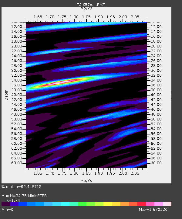
X57A Johnson Farm, Hartsville, SC, USA - Earthquake Result Viewer
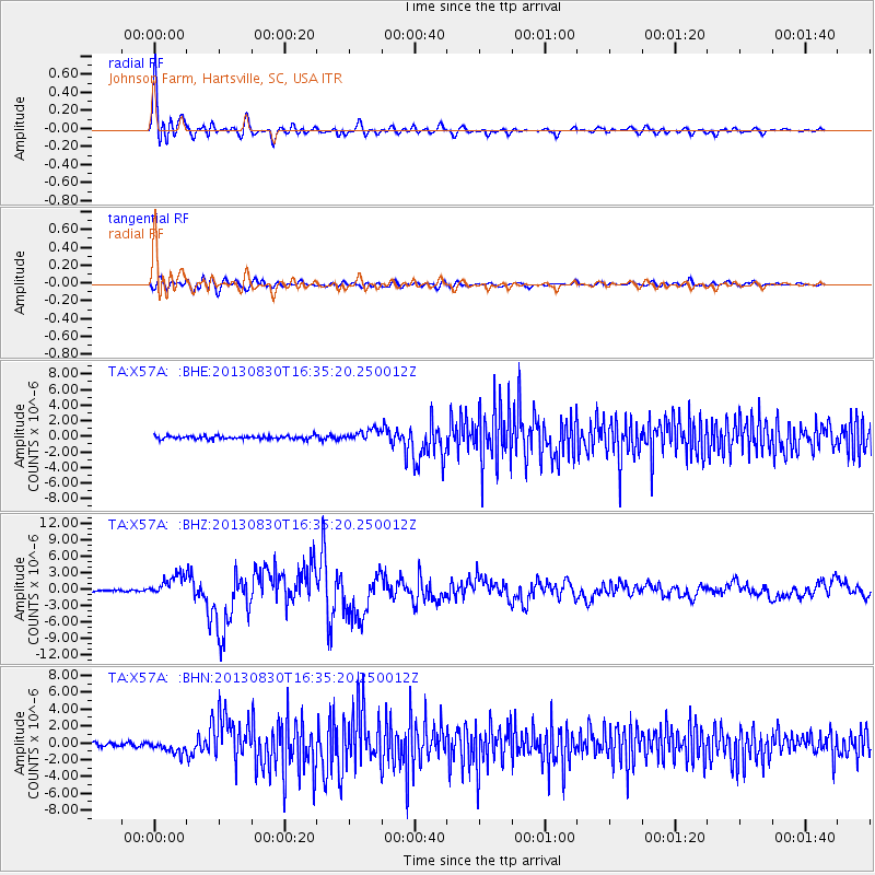
Earthquake location: Andreanof Islands, Aleutian Is.
Earthquake latitude/longitude: 51.5/-175.2
Earthquake time(UTC): 2013/08/30 (242) 16:25:02 GMT
Earthquake Depth: 29 km
Earthquake Magnitude: 7.0 MWW, 6.5 ML, 6.8 MI, 6.9 MWC, 6.9 MWB, 7.0 MWW, 7.0 MI, 7.0 MWC
Earthquake Catalog/Contributor: NEIC PDE/NEIC COMCAT
Network: TA USArray Transportable Network (new EarthScope stations)
Station: X57A Johnson Farm, Hartsville, SC, USA
Lat/Lon: 34.46 N/80.09 W
Elevation: 133 m
Distance: 66.8 deg
Az: 63.54 deg
Baz: 317.412 deg
Ray Param: 0.05732406
Estimated Moho Depth: 34.75 km
Estimated Crust Vp/Vs: 1.74
Assumed Crust Vp: 6.419 km/s
Estimated Crust Vs: 3.689 km/s
Estimated Crust Poisson's Ratio: 0.25
Radial Match: 92.448715 %
Radial Bump: 400
Transverse Match: 72.89528 %
Transverse Bump: 400
SOD ConfigId: 626651
Insert Time: 2014-04-18 05:30:06.949 +0000
GWidth: 2.5
Max Bumps: 400
Tol: 0.001

Signal To Noise

ChannelStoNSTALTA
TA:X57A: :BHZ:20130830T16:35:20.250012Z13.3055011.9926933E-61.4976463E-7
TA:X57A: :BHN:20130830T16:35:20.250012Z2.8969217.1087373E-72.4538943E-7
TA:X57A: :BHE:20130830T16:35:20.250012Z3.58212077.4994887E-72.093589E-7
Arrivals
Ps4.2 SECOND
PpPs14 SECOND
PsPs/PpSs18 SECOND