X58A Rowland, NC, USA - Earthquake Result Viewer
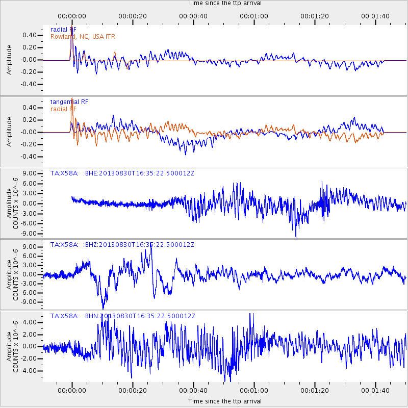
Earthquake location: Andreanof Islands, Aleutian Is.
Earthquake latitude/longitude: 51.5/-175.2
Earthquake time(UTC): 2013/08/30 (242) 16:25:02 GMT
Earthquake Depth: 29 km
Earthquake Magnitude: 7.0 MWW, 6.5 ML, 6.8 MI, 6.9 MWC, 6.9 MWB, 7.0 MWW, 7.0 MI, 7.0 MWC
Earthquake Catalog/Contributor: NEIC PDE/NEIC COMCAT
Network: TA USArray Transportable Network (new EarthScope stations)
Station: X58A Rowland, NC, USA
Lat/Lon: 34.55 N/79.34 W
Elevation: 45 m
Distance: 67.2 deg
Az: 62.974 deg
Baz: 317.616 deg
Ray Param: 0.057090715
Estimated Moho Depth: 10.0 km
Estimated Crust Vp/Vs: 1.74
Assumed Crust Vp: 6.565 km/s
Estimated Crust Vs: 3.773 km/s
Estimated Crust Poisson's Ratio: 0.25
Radial Match: 87.74988 %
Radial Bump: 400
Transverse Match: 70.1467 %
Transverse Bump: 400
SOD ConfigId: 626651
Insert Time: 2014-04-18 05:30:09.911 +0000
GWidth: 2.5
Max Bumps: 400
Tol: 0.001

Signal To Noise

ChannelStoNSTALTA
TA:X58A: :BHZ:20130830T16:35:22.500012Z4.83112572.1323274E-64.4137275E-7
TA:X58A: :BHN:20130830T16:35:22.500012Z2.26362561.264609E-65.5866525E-7
TA:X58A: :BHE:20130830T16:35:22.500012Z1.25192757.7019934E-76.152108E-7
Arrivals
Ps1.2 SECOND
PpPs4.0 SECOND
PsPs/PpSs5.2 SECOND