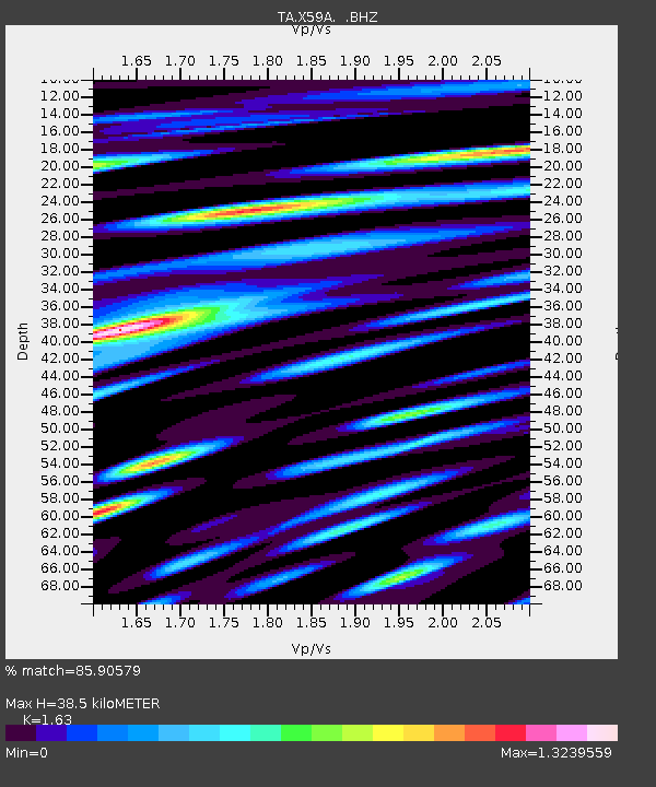
X59A McDuffie Farm, Elizabethtown, NC, USA - Earthquake Result Viewer
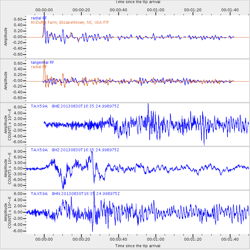
Earthquake location: Andreanof Islands, Aleutian Is.
Earthquake latitude/longitude: 51.5/-175.2
Earthquake time(UTC): 2013/08/30 (242) 16:25:02 GMT
Earthquake Depth: 29 km
Earthquake Magnitude: 7.0 MWW, 6.5 ML, 6.8 MI, 6.9 MWC, 6.9 MWB, 7.0 MWW, 7.0 MI, 7.0 MWC
Earthquake Catalog/Contributor: NEIC PDE/NEIC COMCAT
Network: TA USArray Transportable Network (new EarthScope stations)
Station: X59A McDuffie Farm, Elizabethtown, NC, USA
Lat/Lon: 34.57 N/78.60 W
Elevation: 29 m
Distance: 67.6 deg
Az: 62.474 deg
Baz: 317.84 deg
Ray Param: 0.056832712
Estimated Moho Depth: 38.5 km
Estimated Crust Vp/Vs: 1.63
Assumed Crust Vp: 6.565 km/s
Estimated Crust Vs: 4.027 km/s
Estimated Crust Poisson's Ratio: 0.20
Radial Match: 85.90579 %
Radial Bump: 400
Transverse Match: 63.74845 %
Transverse Bump: 400
SOD ConfigId: 626651
Insert Time: 2014-04-18 05:30:11.543 +0000
GWidth: 2.5
Max Bumps: 400
Tol: 0.001

Signal To Noise

ChannelStoNSTALTA
TA:X59A: :BHZ:20130830T16:35:24.998975Z8.00698952.1136634E-62.639773E-7
TA:X59A: :BHN:20130830T16:35:24.998975Z2.1781439.1726497E-74.2112245E-7
TA:X59A: :BHE:20130830T16:35:24.998975Z1.6099749.964384E-76.189158E-7
Arrivals
Ps3.9 SECOND
PpPs15 SECOND
PsPs/PpSs19 SECOND