Z41A Richland Creek Farm, El Dorado, AR, USA - Earthquake Result Viewer
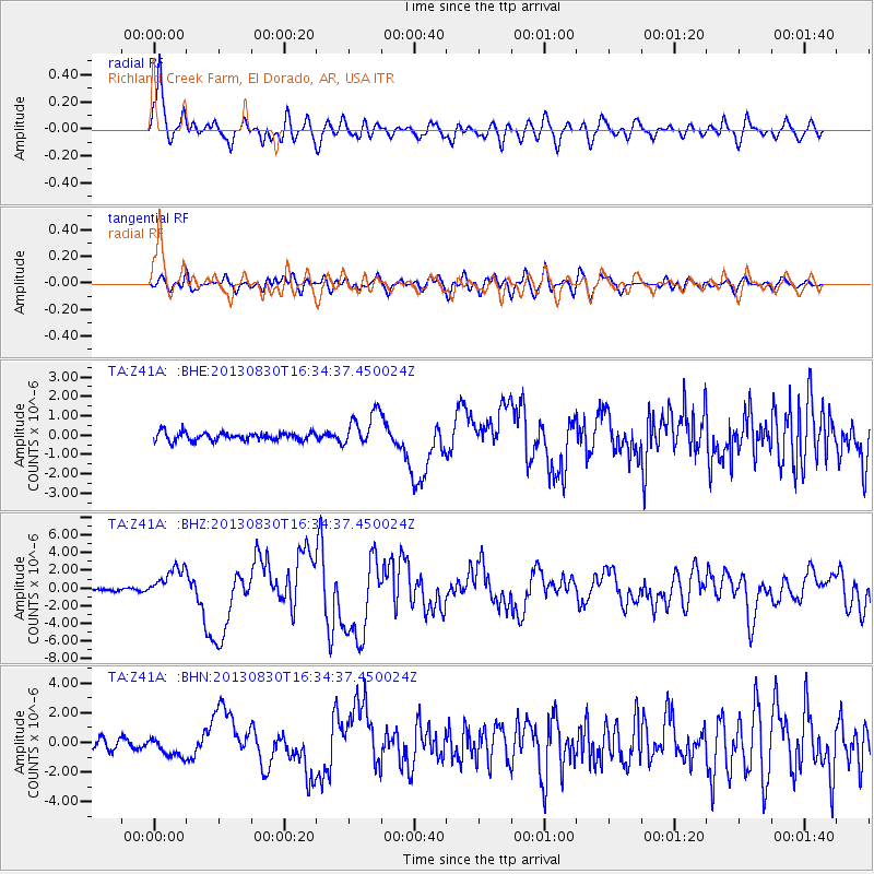
Earthquake location: Andreanof Islands, Aleutian Is.
Earthquake latitude/longitude: 51.5/-175.2
Earthquake time(UTC): 2013/08/30 (242) 16:25:02 GMT
Earthquake Depth: 29 km
Earthquake Magnitude: 7.0 MWW, 6.5 ML, 6.8 MI, 6.9 MWC, 6.9 MWB, 7.0 MWW, 7.0 MI, 7.0 MWC
Earthquake Catalog/Contributor: NEIC PDE/NEIC COMCAT
Network: TA USArray Transportable Network (new EarthScope stations)
Station: Z41A Richland Creek Farm, El Dorado, AR, USA
Lat/Lon: 33.26 N/92.80 W
Elevation: 62 m
Distance: 60.3 deg
Az: 72.954 deg
Baz: 314.549 deg
Ray Param: 0.06156812
Estimated Moho Depth: 11.0 km
Estimated Crust Vp/Vs: 1.60
Assumed Crust Vp: 6.245 km/s
Estimated Crust Vs: 3.903 km/s
Estimated Crust Poisson's Ratio: 0.18
Radial Match: 90.01367 %
Radial Bump: 400
Transverse Match: 70.08655 %
Transverse Bump: 400
SOD ConfigId: 626651
Insert Time: 2014-04-18 05:30:47.382 +0000
GWidth: 2.5
Max Bumps: 400
Tol: 0.001

Signal To Noise

ChannelStoNSTALTA
TA:Z41A: :BHZ:20130830T16:34:37.450024Z7.4995761.7753297E-62.3672399E-7
TA:Z41A: :BHN:20130830T16:34:37.450024Z2.14839746.699827E-73.118523E-7
TA:Z41A: :BHE:20130830T16:34:37.450024Z4.1390648.9774346E-72.1689529E-7
Arrivals
Ps1.1 SECOND
PpPs4.4 SECOND
PsPs/PpSs5.5 SECOND