Z50A Ashland, AL, USA - Earthquake Result Viewer
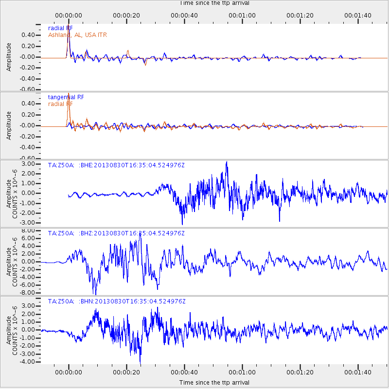
Earthquake location: Andreanof Islands, Aleutian Is.
Earthquake latitude/longitude: 51.5/-175.2
Earthquake time(UTC): 2013/08/30 (242) 16:25:02 GMT
Earthquake Depth: 29 km
Earthquake Magnitude: 7.0 MWW, 6.5 ML, 6.8 MI, 6.9 MWC, 6.9 MWB, 7.0 MWW, 7.0 MI, 7.0 MWC
Earthquake Catalog/Contributor: NEIC PDE/NEIC COMCAT
Network: TA USArray Transportable Network (new EarthScope stations)
Station: Z50A Ashland, AL, USA
Lat/Lon: 33.25 N/85.92 W
Elevation: 370 m
Distance: 64.4 deg
Az: 68.328 deg
Baz: 316.157 deg
Ray Param: 0.05892299
Estimated Moho Depth: 49.25 km
Estimated Crust Vp/Vs: 1.84
Assumed Crust Vp: 6.719 km/s
Estimated Crust Vs: 3.657 km/s
Estimated Crust Poisson's Ratio: 0.29
Radial Match: 97.66529 %
Radial Bump: 356
Transverse Match: 89.312386 %
Transverse Bump: 400
SOD ConfigId: 626651
Insert Time: 2014-04-18 05:30:48.214 +0000
GWidth: 2.5
Max Bumps: 400
Tol: 0.001

Signal To Noise

ChannelStoNSTALTA
TA:Z50A: :BHZ:20130830T16:35:04.524976Z19.5892031.9066763E-69.7333015E-8
TA:Z50A: :BHN:20130830T16:35:04.524976Z7.1702417.72543E-71.0774296E-7
TA:Z50A: :BHE:20130830T16:35:04.524976Z5.09338866.278699E-71.2327155E-7
Arrivals
Ps6.4 SECOND
PpPs20 SECOND
PsPs/PpSs26 SECOND