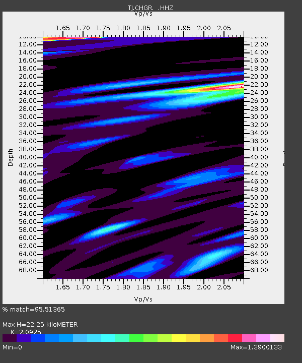
CHGR Chuyangaron, Tajikistan - Earthquake Result Viewer

Earthquake location: Andreanof Islands, Aleutian Is.
Earthquake latitude/longitude: 51.5/-175.2
Earthquake time(UTC): 2013/08/30 (242) 16:25:02 GMT
Earthquake Depth: 29 km
Earthquake Magnitude: 7.0 MWW, 6.5 ML, 6.8 MI, 6.9 MWC, 6.9 MWB, 7.0 MWW, 7.0 MI, 7.0 MWC
Earthquake Catalog/Contributor: NEIC PDE/NEIC COMCAT
Network: TJ Tajikistan National Seismic Network
Station: CHGR Chuyangaron, Tajikistan
Lat/Lon: 38.66 N/69.16 E
Elevation: 1049 m
Distance: 74.1 deg
Az: 312.76 deg
Baz: 35.852 deg
Ray Param: 0.05254118
Estimated Moho Depth: 22.25 km
Estimated Crust Vp/Vs: 2.09
Assumed Crust Vp: 6.483 km/s
Estimated Crust Vs: 3.098 km/s
Estimated Crust Poisson's Ratio: 0.35
Radial Match: 95.51365 %
Radial Bump: 400
Transverse Match: 79.10296 %
Transverse Bump: 400
SOD ConfigId: 626651
Insert Time: 2014-04-18 05:31:08.611 +0000
GWidth: 2.5
Max Bumps: 400
Tol: 0.001

Signal To Noise

ChannelStoNSTALTA
TJ:CHGR: :HHZ:20130830T16:36:04.440015Z26.3330542.8918084E-61.0981668E-7
TJ:CHGR: :HHN:20130830T16:36:04.440015Z9.4569269.705797E-71.0263162E-7
TJ:CHGR: :HHE:20130830T16:36:04.440015Z4.88524.820998E-79.868578E-8
Arrivals
Ps3.9 SECOND
PpPs10 SECOND
PsPs/PpSs14 SECOND