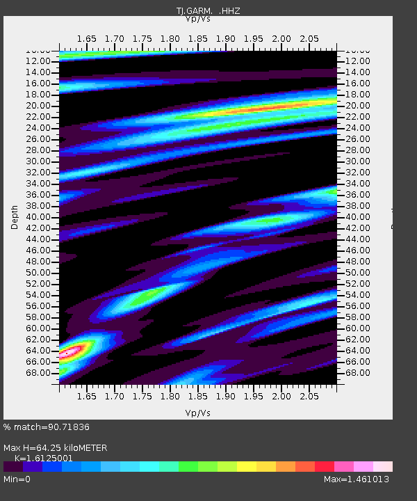
GARM Garm, Tajikistan - Earthquake Result Viewer
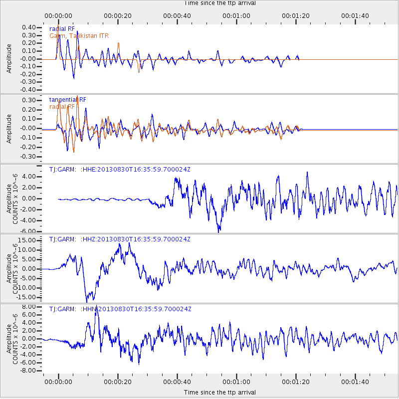
Earthquake location: Andreanof Islands, Aleutian Is.
Earthquake latitude/longitude: 51.5/-175.2
Earthquake time(UTC): 2013/08/30 (242) 16:25:02 GMT
Earthquake Depth: 29 km
Earthquake Magnitude: 7.0 MWW, 6.5 ML, 6.8 MI, 6.9 MWC, 6.9 MWB, 7.0 MWW, 7.0 MI, 7.0 MWC
Earthquake Catalog/Contributor: NEIC PDE/NEIC COMCAT
Network: TJ Tajikistan National Seismic Network
Station: GARM Garm, Tajikistan
Lat/Lon: 39.00 N/70.32 E
Elevation: 1305 m
Distance: 73.3 deg
Az: 312.209 deg
Baz: 36.42 deg
Ray Param: 0.053082664
Estimated Moho Depth: 64.25 km
Estimated Crust Vp/Vs: 1.61
Assumed Crust Vp: 6.306 km/s
Estimated Crust Vs: 3.911 km/s
Estimated Crust Poisson's Ratio: 0.19
Radial Match: 90.71836 %
Radial Bump: 400
Transverse Match: 85.193085 %
Transverse Bump: 400
SOD ConfigId: 626651
Insert Time: 2014-04-18 05:31:11.940 +0000
GWidth: 2.5
Max Bumps: 400
Tol: 0.001

Signal To Noise

ChannelStoNSTALTA
TJ:GARM: :HHZ:20130830T16:35:59.700024Z35.3816683.7049338E-61.0471337E-7
TJ:GARM: :HHN:20130830T16:35:59.700024Z9.6416988.873156E-79.2028976E-8
TJ:GARM: :HHE:20130830T16:35:59.700024Z7.2316997.8979053E-71.0921231E-7
Arrivals
Ps6.5 SECOND
PpPs26 SECOND
PsPs/PpSs32 SECOND