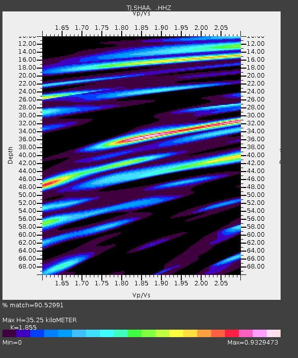
SHAA Shaartuz, Tajikistan - Earthquake Result Viewer
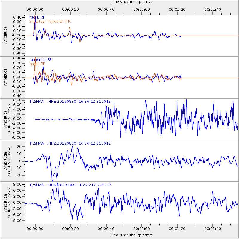
Earthquake location: Andreanof Islands, Aleutian Is.
Earthquake latitude/longitude: 51.5/-175.2
Earthquake time(UTC): 2013/08/30 (242) 16:25:02 GMT
Earthquake Depth: 29 km
Earthquake Magnitude: 7.0 MWW, 6.5 ML, 6.8 MI, 6.9 MWC, 6.9 MWB, 7.0 MWW, 7.0 MI, 7.0 MWC
Earthquake Catalog/Contributor: NEIC PDE/NEIC COMCAT
Network: TJ Tajikistan National Seismic Network
Station: SHAA Shaartuz, Tajikistan
Lat/Lon: 37.56 N/68.12 E
Elevation: 868 m
Distance: 75.4 deg
Az: 312.79 deg
Baz: 35.223 deg
Ray Param: 0.051632535
Estimated Moho Depth: 35.25 km
Estimated Crust Vp/Vs: 1.86
Assumed Crust Vp: 6.213 km/s
Estimated Crust Vs: 3.35 km/s
Estimated Crust Poisson's Ratio: 0.30
Radial Match: 90.52991 %
Radial Bump: 400
Transverse Match: 86.60759 %
Transverse Bump: 400
SOD ConfigId: 626651
Insert Time: 2014-04-18 05:31:16.202 +0000
GWidth: 2.5
Max Bumps: 400
Tol: 0.001

Signal To Noise

ChannelStoNSTALTA
TJ:SHAA: :HHZ:20130830T16:36:12.31001Z34.651074.649967E-61.3419405E-7
TJ:SHAA: :HHN:20130830T16:36:12.31001Z13.4720091.5736352E-61.1680777E-7
TJ:SHAA: :HHE:20130830T16:36:12.31001Z3.4930195.0809115E-71.4545901E-7
Arrivals
Ps5.0 SECOND
PpPs16 SECOND
PsPs/PpSs21 SECOND