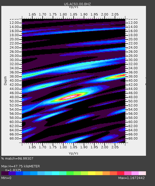
ACSO Alum Creek State Park, Ohio, USA - Earthquake Result Viewer
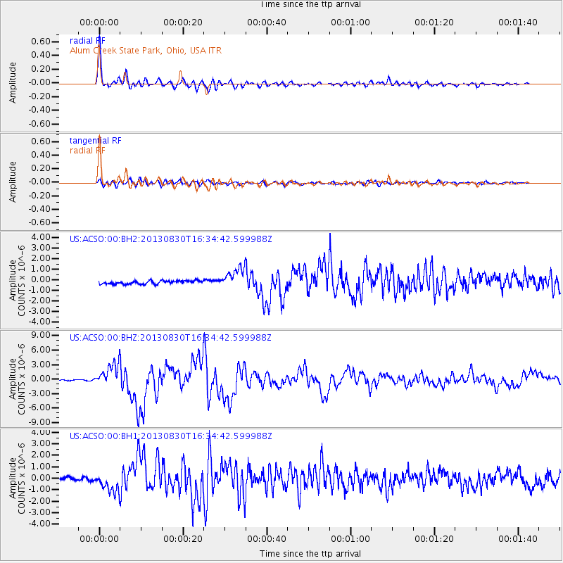
Earthquake location: Andreanof Islands, Aleutian Is.
Earthquake latitude/longitude: 51.5/-175.2
Earthquake time(UTC): 2013/08/30 (242) 16:25:02 GMT
Earthquake Depth: 29 km
Earthquake Magnitude: 7.0 MWW, 6.5 ML, 6.8 MI, 6.9 MWC, 6.9 MWB, 7.0 MWW, 7.0 MI, 7.0 MWC
Earthquake Catalog/Contributor: NEIC PDE/NEIC COMCAT
Network: US United States National Seismic Network
Station: ACSO Alum Creek State Park, Ohio, USA
Lat/Lon: 40.23 N/82.98 W
Elevation: 288 m
Distance: 61.1 deg
Az: 60.93 deg
Baz: 314.517 deg
Ray Param: 0.0610662
Estimated Moho Depth: 47.75 km
Estimated Crust Vp/Vs: 1.83
Assumed Crust Vp: 6.498 km/s
Estimated Crust Vs: 3.546 km/s
Estimated Crust Poisson's Ratio: 0.29
Radial Match: 96.99307 %
Radial Bump: 400
Transverse Match: 80.45489 %
Transverse Bump: 400
SOD ConfigId: 626651
Insert Time: 2014-04-18 05:31:46.519 +0000
GWidth: 2.5
Max Bumps: 400
Tol: 0.001

Signal To Noise

ChannelStoNSTALTA
US:ACSO:00:BHZ:20130830T16:34:42.599988Z23.839432.4486935E-61.02716115E-7
US:ACSO:00:BH1:20130830T16:34:42.599988Z3.82588728.109835E-72.1197266E-7
US:ACSO:00:BH2:20130830T16:34:42.599988Z6.45424039.836185E-71.523988E-7
Arrivals
Ps6.4 SECOND
PpPs20 SECOND
PsPs/PpSs26 SECOND