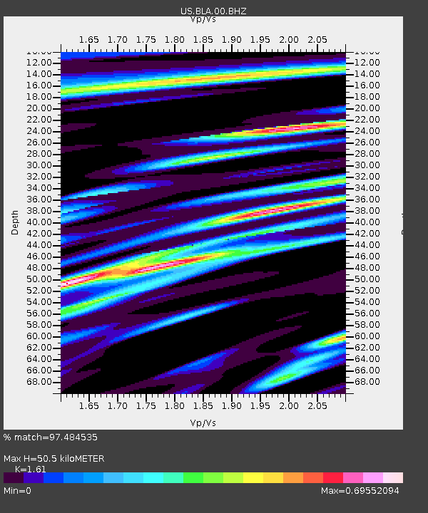
BLA Blacksburg, Virginia, USA - Earthquake Result Viewer
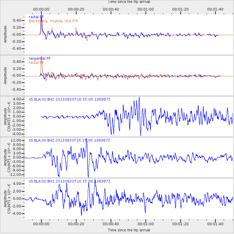
Earthquake location: Andreanof Islands, Aleutian Is.
Earthquake latitude/longitude: 51.5/-175.2
Earthquake time(UTC): 2013/08/30 (242) 16:25:02 GMT
Earthquake Depth: 29 km
Earthquake Magnitude: 7.0 MWW, 6.5 ML, 6.8 MI, 6.9 MWC, 6.9 MWB, 7.0 MWW, 7.0 MI, 7.0 MWC
Earthquake Catalog/Contributor: NEIC PDE/NEIC COMCAT
Network: US United States National Seismic Network
Station: BLA Blacksburg, Virginia, USA
Lat/Lon: 37.21 N/80.42 W
Elevation: 634 m
Distance: 64.6 deg
Az: 61.699 deg
Baz: 316.464 deg
Ray Param: 0.058757342
Estimated Moho Depth: 50.5 km
Estimated Crust Vp/Vs: 1.61
Assumed Crust Vp: 6.159 km/s
Estimated Crust Vs: 3.825 km/s
Estimated Crust Poisson's Ratio: 0.19
Radial Match: 97.484535 %
Radial Bump: 400
Transverse Match: 88.8049 %
Transverse Bump: 400
SOD ConfigId: 626651
Insert Time: 2014-04-18 05:31:57.156 +0000
GWidth: 2.5
Max Bumps: 400
Tol: 0.001

Signal To Noise

ChannelStoNSTALTA
US:BLA:00:BHZ:20130830T16:35:06.198987Z17.697582.2519105E-61.2724396E-7
US:BLA:00:BH1:20130830T16:35:06.198987Z5.36573038.139787E-71.5169952E-7
US:BLA:00:BH2:20130830T16:35:06.198987Z4.5214926.365102E-71.4077438E-7
Arrivals
Ps5.2 SECOND
PpPs21 SECOND
PsPs/PpSs26 SECOND