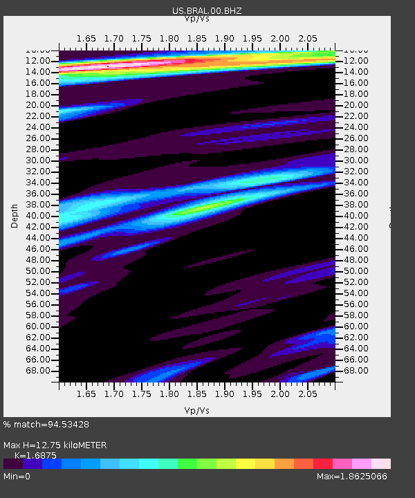
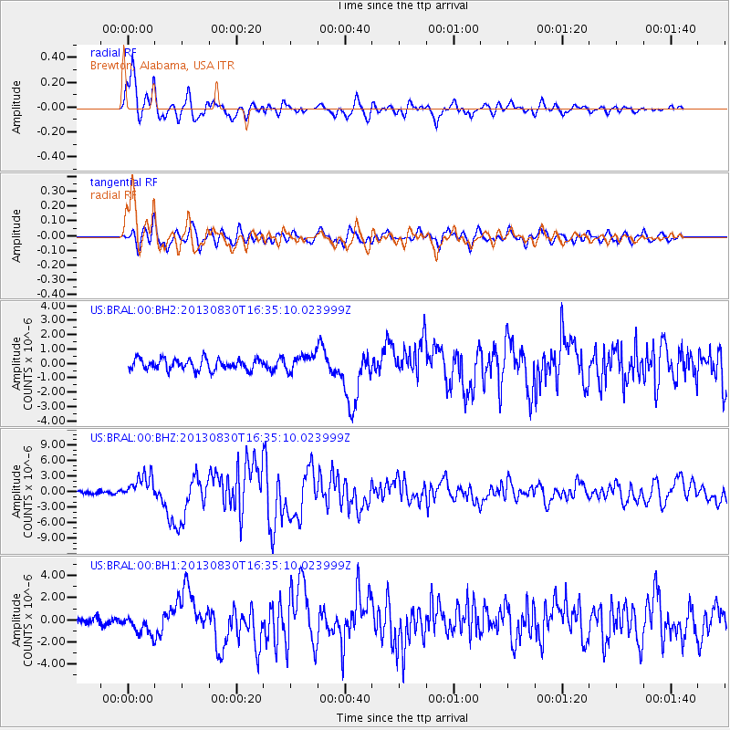
BRAL Brewton, Alabama, USA - Earthquake Result Viewer

Earthquake location: Andreanof Islands, Aleutian Is.
Earthquake latitude/longitude: 51.5/-175.2
Earthquake time(UTC): 2013/08/30 (242) 16:25:02 GMT
Earthquake Depth: 29 km
Earthquake Magnitude: 7.0 MWW, 6.5 ML, 6.8 MI, 6.9 MWC, 6.9 MWB, 7.0 MWW, 7.0 MI, 7.0 MWC
Earthquake Catalog/Contributor: NEIC PDE/NEIC COMCAT
Network: US United States National Seismic Network
Station: BRAL Brewton, Alabama, USA
Lat/Lon: 31.01 N/87.06 W
Elevation: 61 m
Distance: 65.3 deg
Az: 70.801 deg
Baz: 316.608 deg
Ray Param: 0.058303017
Estimated Moho Depth: 12.75 km
Estimated Crust Vp/Vs: 1.69
Assumed Crust Vp: 6.187 km/s
Estimated Crust Vs: 3.666 km/s
Estimated Crust Poisson's Ratio: 0.23
Radial Match: 94.53428 %
Radial Bump: 400
Transverse Match: 84.6756 %
Transverse Bump: 400
SOD ConfigId: 626651
Insert Time: 2014-04-18 05:32:04.855 +0000
GWidth: 2.5
Max Bumps: 400
Tol: 0.001

Signal To Noise

ChannelStoNSTALTA
US:BRAL:00:BHZ:20130830T16:35:10.023999Z8.92775252.356476E-62.6394954E-7
US:BRAL:00:BH1:20130830T16:35:10.023999Z2.7536679.3511284E-73.395882E-7
US:BRAL:00:BH2:20130830T16:35:10.023999Z2.13213138.193689E-73.8429567E-7
Arrivals
Ps1.5 SECOND
PpPs5.3 SECOND
PsPs/PpSs6.8 SECOND