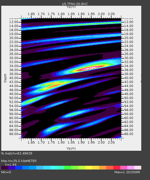
TPNV Topopah Spring, Nevada, USA - Earthquake Result Viewer

Earthquake location: Andreanof Islands, Aleutian Is.
Earthquake latitude/longitude: 51.5/-175.2
Earthquake time(UTC): 2013/08/30 (242) 16:25:02 GMT
Earthquake Depth: 29 km
Earthquake Magnitude: 7.0 MWW, 6.5 ML, 6.8 MI, 6.9 MWC, 6.9 MWB, 7.0 MWW, 7.0 MI, 7.0 MWC
Earthquake Catalog/Contributor: NEIC PDE/NEIC COMCAT
Network: US United States National Seismic Network
Station: TPNV Topopah Spring, Nevada, USA
Lat/Lon: 36.95 N/116.25 W
Elevation: 1600 m
Distance: 43.5 deg
Az: 85.718 deg
Baz: 308.972 deg
Ray Param: 0.072451815
Estimated Moho Depth: 35.0 km
Estimated Crust Vp/Vs: 1.94
Assumed Crust Vp: 6.279 km/s
Estimated Crust Vs: 3.236 km/s
Estimated Crust Poisson's Ratio: 0.32
Radial Match: 92.49929 %
Radial Bump: 400
Transverse Match: 78.86542 %
Transverse Bump: 400
SOD ConfigId: 626651
Insert Time: 2014-04-18 05:33:40.495 +0000
GWidth: 2.5
Max Bumps: 400
Tol: 0.001

Signal To Noise

ChannelStoNSTALTA
US:TPNV:00:BHZ:20130830T16:32:32.499005Z10.0241268.1198596E-78.1003165E-8
US:TPNV:00:BH1:20130830T16:32:32.499005Z4.37772133.5952488E-78.212603E-8
US:TPNV:00:BH2:20130830T16:32:32.499005Z4.20875643.2789478E-77.790776E-8
Arrivals
Ps5.5 SECOND
PpPs15 SECOND
PsPs/PpSs21 SECOND