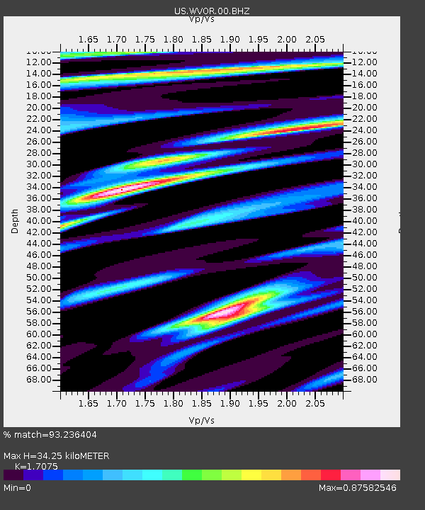
WVOR Wild Horse Valley, Oregon, USA - Earthquake Result Viewer
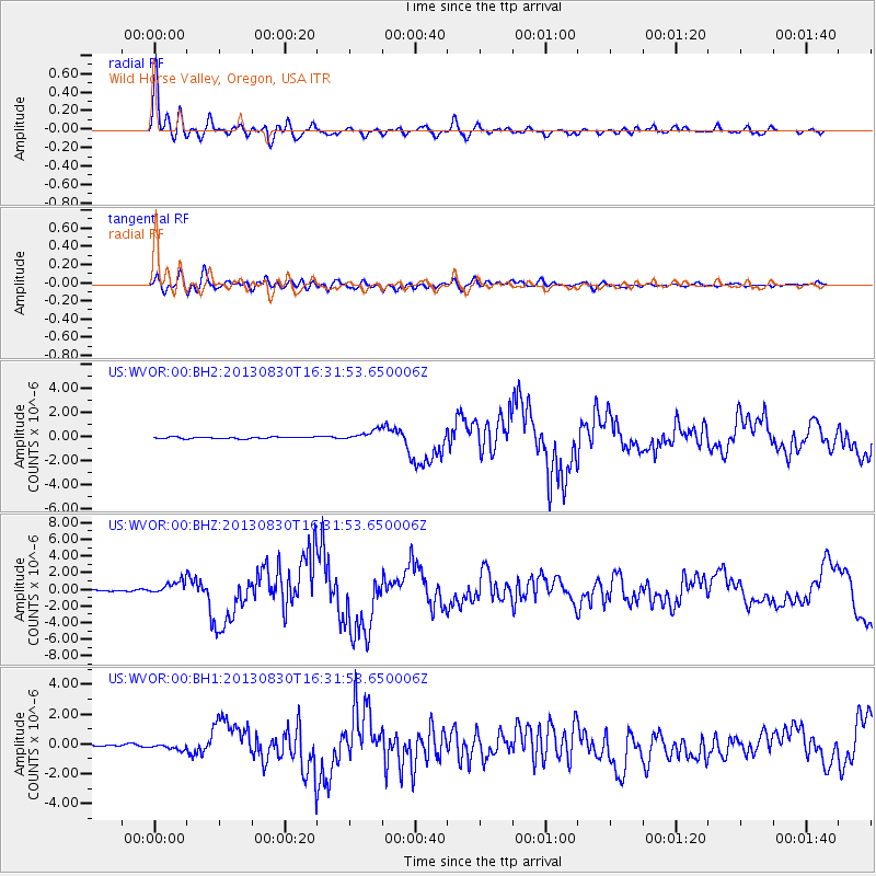
Earthquake location: Andreanof Islands, Aleutian Is.
Earthquake latitude/longitude: 51.5/-175.2
Earthquake time(UTC): 2013/08/30 (242) 16:25:02 GMT
Earthquake Depth: 29 km
Earthquake Magnitude: 7.0 MWW, 6.5 ML, 6.8 MI, 6.9 MWC, 6.9 MWB, 7.0 MWW, 7.0 MI, 7.0 MWC
Earthquake Catalog/Contributor: NEIC PDE/NEIC COMCAT
Network: US United States National Seismic Network
Station: WVOR Wild Horse Valley, Oregon, USA
Lat/Lon: 42.43 N/118.64 W
Elevation: 1344 m
Distance: 38.8 deg
Az: 80.668 deg
Baz: 303.644 deg
Ray Param: 0.07531455
Estimated Moho Depth: 34.25 km
Estimated Crust Vp/Vs: 1.71
Assumed Crust Vp: 6.279 km/s
Estimated Crust Vs: 3.677 km/s
Estimated Crust Poisson's Ratio: 0.24
Radial Match: 93.236404 %
Radial Bump: 400
Transverse Match: 68.42645 %
Transverse Bump: 400
SOD ConfigId: 626651
Insert Time: 2014-04-18 05:33:50.691 +0000
GWidth: 2.5
Max Bumps: 400
Tol: 0.001

Signal To Noise

ChannelStoNSTALTA
US:WVOR:00:BHZ:20130830T16:31:53.650006Z8.2125168.1875146E-79.969557E-8
US:WVOR:00:BH1:20130830T16:31:53.650006Z1.19237791.4474553E-71.2139233E-7
US:WVOR:00:BH2:20130830T16:31:53.650006Z5.9392154.417865E-77.4384666E-8
Arrivals
Ps4.1 SECOND
PpPs14 SECOND
PsPs/PpSs18 SECOND