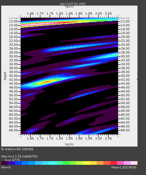
CCUT Cedar City, UT, USA - Earthquake Result Viewer

Earthquake location: Andreanof Islands, Aleutian Is.
Earthquake latitude/longitude: 51.5/-175.2
Earthquake time(UTC): 2013/08/30 (242) 16:25:02 GMT
Earthquake Depth: 29 km
Earthquake Magnitude: 7.0 MWW, 6.5 ML, 6.8 MI, 6.9 MWC, 6.9 MWB, 7.0 MWW, 7.0 MI, 7.0 MWC
Earthquake Catalog/Contributor: NEIC PDE/NEIC COMCAT
Network: UU University of Utah Regional Network
Station: CCUT Cedar City, UT, USA
Lat/Lon: 37.55 N/113.36 W
Elevation: 2127 m
Distance: 44.9 deg
Az: 82.975 deg
Baz: 308.746 deg
Ray Param: 0.07156075
Estimated Moho Depth: 13.25 km
Estimated Crust Vp/Vs: 1.68
Assumed Crust Vp: 6.194 km/s
Estimated Crust Vs: 3.693 km/s
Estimated Crust Poisson's Ratio: 0.22
Radial Match: 95.349365 %
Radial Bump: 359
Transverse Match: 85.02812 %
Transverse Bump: 400
SOD ConfigId: 626651
Insert Time: 2014-04-18 05:34:00.045 +0000
GWidth: 2.5
Max Bumps: 400
Tol: 0.001

Signal To Noise

ChannelStoNSTALTA
UU:CCUT:01:HHZ:20130830T16:32:43.81001Z8.2922018.34953E-71.0069136E-7
UU:CCUT:01:HHN:20130830T16:32:43.81001Z5.4454093.2644044E-75.994783E-8
UU:CCUT:01:HHE:20130830T16:32:43.81001Z4.33724163.8699264E-78.9225516E-8
Arrivals
Ps1.5 SECOND
PpPs5.4 SECOND
PsPs/PpSs6.9 SECOND