LEBA Lebam, WA, USA - Earthquake Result Viewer
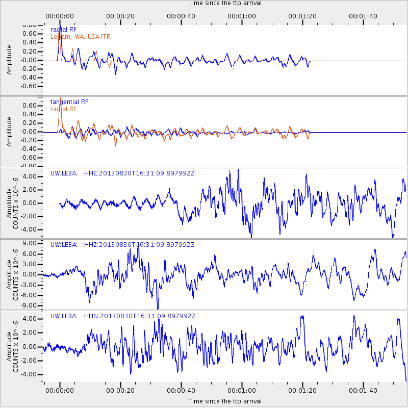
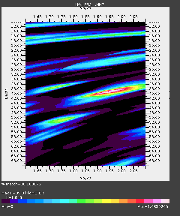
Earthquake location: Andreanof Islands, Aleutian Is.
Earthquake latitude/longitude: 51.5/-175.2
Earthquake time(UTC): 2013/08/30 (242) 16:25:02 GMT
Earthquake Depth: 29 km
Earthquake Magnitude: 7.0 MWW, 6.5 ML, 6.8 MI, 6.9 MWC, 6.9 MWB, 7.0 MWW, 7.0 MI, 7.0 MWC
Earthquake Catalog/Contributor: NEIC PDE/NEIC COMCAT
Network: UW Pacific Northwest Regional Seismic Network
Station: LEBA Lebam, WA, USA
Lat/Lon: 46.55 N/123.56 W
Elevation: 73 m
Distance: 33.6 deg
Az: 77.743 deg
Baz: 297.837 deg
Ray Param: 0.07806927
Estimated Moho Depth: 39.0 km
Estimated Crust Vp/Vs: 1.95
Assumed Crust Vp: 6.566 km/s
Estimated Crust Vs: 3.376 km/s
Estimated Crust Poisson's Ratio: 0.32
Radial Match: 88.100075 %
Radial Bump: 400
Transverse Match: 60.79072 %
Transverse Bump: 400
SOD ConfigId: 626651
Insert Time: 2014-04-18 05:35:17.016 +0000
GWidth: 2.5
Max Bumps: 400
Tol: 0.001

Signal To Noise

ChannelStoNSTALTA
UW:LEBA: :HHZ:20130830T16:31:09.897992Z4.28941069.1349153E-72.1296434E-7
UW:LEBA: :HHN:20130830T16:31:09.897992Z1.00061713.4592466E-73.457113E-7
UW:LEBA: :HHE:20130830T16:31:09.897992Z1.49767515.726741E-73.8237536E-7
Arrivals
Ps6.0 SECOND
PpPs16 SECOND
PsPs/PpSs22 SECOND